
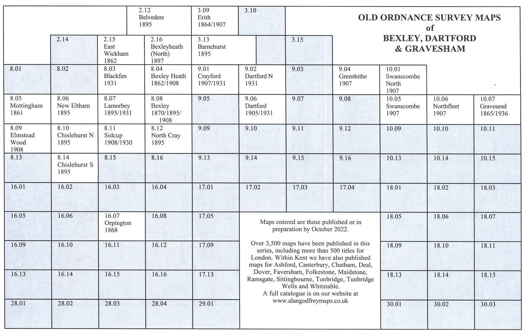
Old Ordnance Survey Maps of Kent and Medway
We have a range of detailed maps for Kent towns, and we also cover the whole county at the Inch to the Mile scale. During 2022-24 we have greatly expanded our coverage of
Dartford, Gravesham and Medway.
All maps are available from our On-line Mapshop.
Kent is a two-tier county. Medway is a unitary council. The rest of the county is administered by 12 Districts,
Ashford, Canterbury, Dartford, Dover, Folkestone & Hythe, Gravesham, Maidstone, Sevenoaks, Swale, Thanet,, Tonbridge & Malling, and |Tunbridge Wells.
For a summary of the county's local government history visit This Page.
In 1965 the Bexley and Bromley areas became London boroughs and are listed separately in our series.
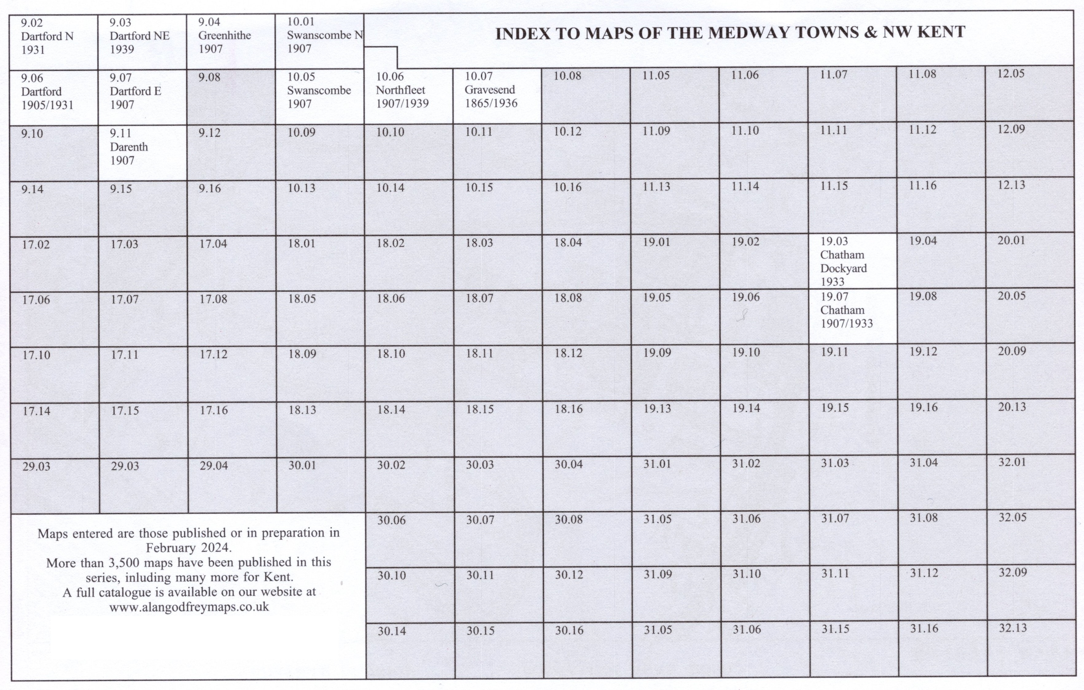
Medway
- 19.02 Strood & Rochester Bridge 1931 - published 2024; intro by Pamela Taylor
- 19.03 Chatham Dockyard & East Frindsbury 1933 - published 2024; intro by Pamela Taylor
- 19.04 Gillingham (North) 1933- published 2024; intro by Pamela Taylor
- 19.06 Rochester (West) 1931 - published 2024; intro by Pamela Taylor
- 19.07a Chatham 1907 - published 2002; intro by Alan Godfrey
- 19.07b Chatham & Rochester (East) 1933 - published 2024; intro by Pamela Taylor
- 19.08 Central Gillingham 1932- published 2024; intro by Pamela Taylor
- 19.11 Chatham (South) & Fort Luton 1932- published 2024; intro by Pamela Taylor
- 19.12 Luton & Darland 1932- published 2024; intro by Pamela Taylor
- 20.09 Rainham (West) 1931- published 2024; intro by Pamela Taylor
- 20.10 Rainham (East) & Otterham Quay 1931- published 2024; intro by Pamela Taylor
Dartford and Gravesham
- 03.14 Dartford Marshes (Joyce Green & Slade Green) 1907 - published 2023; intro by Alan Godfrey
- 09.02 Dartford (North) & Crayford East 1931 - published 2022; intro by Pamela Taylor
- 09.03 Dartford NE & Long Reach 1939 - published 2023; intro by Alan Godfrey
- 09.04 Greenhithe & Stone 1907 - published 2022; intro by Pamela Taylor
- 09.06a Dartford 1905 - published 2010; intro by Barrie Trinder
- 09.06b Dartford 1931 - published 2022; intro by Pamela Taylor
- 09.07 Dartford (East) & Stone (West) 1907 - published 2023; intro by Pamela Taylor
- 09.11 Darenth 1907 - published 2023; intro by Pamela Taylor
- 10.01 Swanscombe North & Northfleet NW 1907 - published 2022; intro by Pamela Taylor
- 10.05 Swanscombe 1907 - published 2022; intro by Pamela Taylor
- 10.06a Northfleet 1907 - published 1999; intro by Alan Godfrey
- 10.06b Northfleet & West Gravesend 1939 - published 2023; intro by Pamela Taylor
- 10.07a Gravesend 1865 - published 2001; intro by Alan Godfrey
- 10.07b Gravesend 1936 - published 2023; intro by Pamela Taylor
Other areas of Kent
- 13.06 Sheerness 1931 - published 2008; intro by Pamela Taylor
- 23.10 Whitstable (North) 1906 - published 2014; intro by Barrie Trinder
- 23.13 Whitstable (West) 1905 - published 2014; intro by Barrie Trinder
- 23.14 Whitstable (East) 1906 - published 2014; intro by Barrie Trinder
- 25.04 Margate (North) 1896 - published 2010; intro by Barrie Trinder
- 25.08 Margate (South) 1896 - published 2010; intro by Barrie Trinder
- 33.01 Sittingbourne 1897 - published 2012; intro by Barrie Trinder
- 34.09 Faversham (SW) & Ospringe 1906 - published 2004; intro by Arthur Percival
- 34.10 Faversham (SE) 1906 - published 2005; intro by Arthur Percival
- 38.01 Ramsgate 1905 - published 2009; intro by Pamela Taylor
- 40.01 Sevenoaks (N) 1907 - published 2014; intro by Pamela Taylor
- 40.05 Sevenoaks (S) 1907 - published 2014; intro by Pamela Taylor
- 42.03 Maidstone (North) 1868 - published 1998; intro by Peter Bagshaw
- 42.07 Maidstone (South) 1868 - published 1998; intro by Peter Bagshaw
- 46.03 Canterbury 1906 - published 2010; intro by Barrie Trinder
- 50.12 Tonbridge 1895 - published 2000; intro by Peter Bagshaw
- 58.04 Deal 1871 - published 1991; intro by Elizabeth Lockwood
- 60.11 Tunbridge Wells (NW) 1907 - published 2004; intro by Peter Bagshaw
- 60.12 Tunbridge Wells (NE) 1907 - published 2005; intro by Peter Bagshaw
- 60.15 Tunbridge Wells (SW) 1907 - published 2004; intro by Peter Bagshaw
- 60.16 Tunbridge Wells (SE) 1907 - published 2008; intro by Phillip Whitbourn
- 65.05 Ashford 1896 - published 2014; intro by Barrie Trinder
- 65.09 Ashford (South) 1896 - published 2014; intro by Barrie Trinder
- 68.14 Dover (South) 1897 - published 2003; intro by Alan Godfrey
- 75.10 Folkestone 1906 - published 2000; intro by Alan Godfrey
Inch to the Mile maps
- 274 Dartford & Gravesend 271 - published 2011, intro by Barrie Trinder. Includes a map of Betsham.
- 272 The Medway Towns 1893 - published 2003, intro by Tony Painter. Includes a map of Minster.
- 273 North Kent Coast 1878 - published 2001, intro by John Whyman. Includes a map of Sarre.
- 274 Isle of Thanet 1893 - published 2009, intro by Barrie Trinder. Includes a map of Minster.
- 287 Sevenoaks & Tonbridge 1893 - published 2011, intro by Barrie Trinder. Includes a map of Wrotham.
- 288 Maidstone & District 1893 - published 2010, intro by Barrie Trinder. Includes a map of Hollingbourne.
- 289 Canterbury & Ashford 1888 - published 2009, intro by Barrie Trinder. Includes a map of Wye.
- 290 Dover & Sandwich 1893 - published 2009, intro by Barrie Trinder. Includes a map of Eastry.
- 303 Tunbridge Wells & Ashdown Forest 1894 - published 2011; intro by Barrie Trinder. Includes a map of Mayfield.
- 304 Tenterden & District 1893 - published 2010; intro by Barrie Trinder. Includes a map of Tenterden.
- 305 Folkestone & Romney Marsh 1893 - published 2008; intro by Barrie Trinder. Includes a map of Old Romney.

- Most maps in the Godfrey Edition are taken from the 25 inch to the mile map and reduced to about 15 inches to the mile.
For a full list of English maps, return to the England page
- Alan Godfrey Maps, Prospect Business Park, Leadgate, Consett, DH8 7PW. Tel 01207 583388
The Godfrey Edition / sales@alangodfreymaps.co.uk / 3 December 2024