
 Here are the details of maps for Merton:

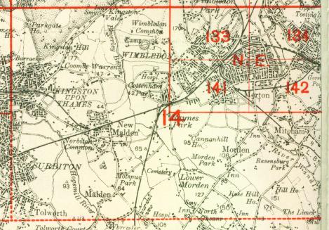
We have published just the one version of this map. It covers an area around the former Merton Abbey and stretches from Morden Road eastward to London Road and Tooting Junction, from Collier's Wood southward to Upper Mitcham. Features include Holborn Union Workhouse, Holborn Industrial Schools, both at Upper Mitcham; Merton Abbey station with a siding to Abbey Mills, Morden station (on the Croydon & Wimbledon line), Nelson's Fields, several varnish factories by the River Wandle, High Street, Quicks Road, and the eastern fringe of South Wimbledon. Several extracts from Trim's Directory 1909 appear on the back.
The map links up with London Sheets 134 Tooting to the north, 141 South Wimbledon to the west, 143 Lower Streatham to the east; and Surrey sheet 13.03 Morden to the south.
 Follow this link for a complete list of our London maps .