
 Here are the details of maps for South Wimbledon:

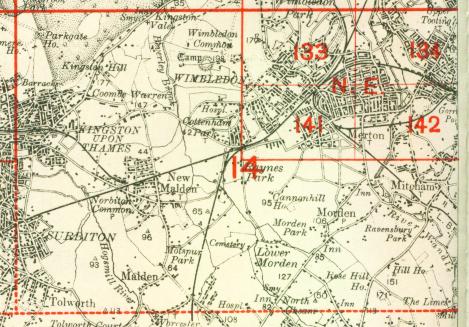
We have published just the one version of this map. It covers an area stretching from Pepys Road and the east end of Raynes Park station eastward to Montague Road and Merton Park station; and from the south end of Wimbledon station and The Broadway southward to Manor Farm and Mostyn Road. It therefore covers the southern end of Wimbledon. (We regret that sheet 133 Central Wimbledon is not yet available in The Godfrey Edition.) Features on the map include Wimbledon College, Worple Road, Mertonhall Farm, west and south railway approaches to Wimbledon, the original All England tennis ground, Kingston Road. Street directory extracts are included for Denmark Rd, Graham Rd, Hartfield Crescent, Hartfield Rd, Palmerston Grove, Thornton Hill.
The map links up with London Sheets 133 Wimbledon to the north, 142 Merton to the east.
 Follow this link for a complete list of our London maps .