Old Ordnance Survey Town Plans of London

  • These highly detailed maps, at a scale of 1:1760 or a Yard to the Mile, cover parts of central London in exceptional detail. They are available through our On-line Mapshop

  • Here are the details of the map for south Stratford:

  • London Large Scale Sheet 08.22 Stratford (South) 1867-93 - published 2024. Intro by Tony Kirby. ISBN.978-1-78721-781-2

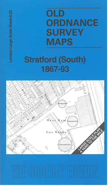
    This very detailed map covers the southern part of Stratford. Features include Stratford Bridge, Channel Sea Bridge, Great Eastern Railway with Stratford Market station, Chant Square, schools, London Spinning Mills, Christ Church, West Ham Gasworks.

    On the reverse we include the 1893 map of the same area, now including Stratford Market, the GER goods depot, and more housing. A 2,000 word introduction is also included.

    The map links up with sheet 8.12 Stratford to the north.


  • For other Town Plans go to the London Town Plans page. Here is an Index Grid
  • For a full list of maps for London and Middlesex, return to the London page.
  • For other information and prices, and other areas, go to The Home Page.
    Alan Godfrey Maps, Prospect Business Park, Leadgate, Consett, DH8 7PW. Tel 01207 583388
    The Godfrey Edition / sales@alangodfreymaps.co.uk / 30 Augut 2024