Old Ordnance Survey Maps of London

  • These detailed maps maps normally cover an area of about one and a half miles by one mile. Each map includes an introduction. The London maps link up with those for Middlesex to form a major series for the Greater London area. They are available through our On-line Mapshop

  • Here are the details of maps for central Croydon :

  • London Sheet 157 Croydon 1895 - published 2014; intro by Richard Oliver. ISBN.978-1-84784-798-0

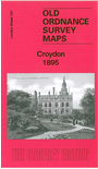
    This detailed map covers much of central Croydon, with coverage stretching from Waddon Mills eastward to Croydon East station, and southward to Bramley Hill.

    Features include railways with East Croydon station, Waddon station, Town Hall, tramways, The Waldrons, Whitgift Grammar School, town centre with individual buildings neatly shown, Duppas House, Reliance Iron Works, brewery, Waddon Mills with railway, Waddon House, churches etc.

    The map links up with London sheets 154 Croydon NW to the north and 159 South Croydon to the south.


  • Follow this link for a complete list of our Croydon maps.
  • You can order maps direct from our On-line Mapshop. For other information and prices, and other areas, go to The Index Page.
  • Maps in the Godfrey Edition are taken from the 25 inch to the mile map and reduced to about 15 inches to the mile. For a full list of maps for England, return to the England page.
    Alan Godfrey Maps, Prospect Business Park, Leadgate, Consett, Co Durham, DH8 7PW / sales@alangodfreymaps.co.uk / 5 February 2018