OLD ORDNANCE SURVEY MAPS
The Godfrey Edition
These maps are invaluable for historians and genealogists.
More than 2,000 titles have been issued in this major series of
reprints of Old Ordnance Survey Maps of towns throughout
Britain and Ireland. Follow the links below for a complete catalogue.
 25 YEARS OF THE GODFREY EDITION. This winter we have been celebrating the 25th Anniversary of our publishing business. To
mark the occasion we sponsored a production of Donizetti's La Fille du Regiment, performed by Swansea City Opera, at our local
Empire Theatre, Consett, followed by a reception attended by several of our authors and many friends.
25 YEARS OF THE GODFREY EDITION. This winter we have been celebrating the 25th Anniversary of our publishing business. To
mark the occasion we sponsored a production of Donizetti's La Fille du Regiment, performed by Swansea City Opera, at our local
Empire Theatre, Consett, followed by a reception attended by several of our authors and many friends.
Most of the maps are highly detailed, taken from the 1/2500 plans and
reprinted at about 14 inches to the mile. They cover towns in great detail, showing individual houses,
railway tracks, factories, churches, mills, canals, tramways
and even minutiae such as dockside cranes, fountains,
signal posts, pathways, sheds, wells, etc.. Each map includes historical notes on the area concerned.
Many also include extracts from contemporary directories.
The maps are neatly folded, often with an early photograph on
the cover. The maps are ideal for local historians, transport historians,
and family historians, or simply those with an interest in the
town they live in or have visited. The maps are very good value and cost just £ 2.25 each. Details of postage costs are
given further down the page.
We have our own On-line Mapshop. It has been designed to be simple and secure,
and enables us to provide a quick and efficient service. We hope you will visit it. However I do strongly recommend you look at and explore our catalogue beforehand; follow the
various links below.
The current catalogue appears on the following pages:
The maps are highly detailed so they do not cover a large area.
Most maps are for an area of about one and a half square miles -
normally one mile upwards, one and a half miles across - so
do not expect them to include a village a few miles away!
However, in many areas, such as London, Merseyside, Tyneside,
etc. we publish adjacent maps, so the sets build up to show a
large area. Our website includes index maps for London to give an
idea of the area covered by each map, and similar indexes are gradually being
added for other areas. Follow the links for further information.
We are also now publishing a series of one inch to the mile maps, giving
coverage of a wider area (though in less detail). We have now issued
over 200 of these maps in England and Wales, plus several in Northern Ireland, and
many others are being prepared.
This site is now more frequently updated than ever, often several times a week, with the frequent addition of
information pages for particular counties or areas. If you would like to have a quick check to see if there is anything new, just go
to this page.
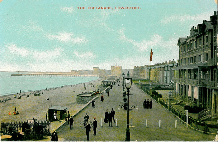
I have kept the files as simple as possible for quick
downloading. However, if you would like to see the sort of
detail which appears on the maps, here is a
small sample:
an extract from the Lowestoft (North) map. We are also now adding index maps for some
towns; see index maps and publications for
further details.
The maps cost just £ 2.25 each in the United Kingdom,
plus 75p per order postage. (ie. 2 maps = £ 5.25) We can accept payment by cheque, postal order,
Visa, Mastercard or Switch.
For overseas orders, maps cost £ 2.25 each plus 10% post &
packing in Europe, 20% in North America, or 25% postage in Rest of the World. Please note we have a
minimum overseas order of £ 5.00 so it is normally worth ordering at least
2 maps!
To visit our On-line Mapshop visit this link.
For other ordering information and a selection of stockists see
our Order Page
Alan Godfrey Maps
Prospect Business Park
Leadgate, Consett, DH8 7PW
England
Tel. (01207) 583388 or Fax (01207) 583399
The Godfrey Edition / For general enquiriessales@alangodfreymaps.co.uk / revised 29 July 2007 25 YEARS OF THE GODFREY EDITION. This winter we have been celebrating the 25th Anniversary of our publishing business. To
mark the occasion we sponsored a production of Donizetti's La Fille du Regiment, performed by Swansea City Opera, at our local
Empire Theatre, Consett, followed by a reception attended by several of our authors and many friends.
25 YEARS OF THE GODFREY EDITION. This winter we have been celebrating the 25th Anniversary of our publishing business. To
mark the occasion we sponsored a production of Donizetti's La Fille du Regiment, performed by Swansea City Opera, at our local
Empire Theatre, Consett, followed by a reception attended by several of our authors and many friends.