
Old Ordnance Survey Maps of Rochdale MBC
This is our coverage of the Metropolitan Borough of Rochdale. This was formed in 1974 with the amalgamation of
the County Borough of Rochdale, Heyood Municipal Borough, Middleton Municipal Borough, Littleborough Urban District, Milnrow Urban District and
Wardle Urban District. Rochdale then also became part of Greater Manchester.
All maps are available from our On-line Mapshop.
The following titles are all taken from the OS 25" maps and reduced to a scale of approximately 14 inches to the mile.
They are extremely detailed, showing individual houses, details such as railway tracks, pathways,
pubs, factories and even minutiae such as fountains and signal posts. Each covers an area of a mile and a half by one mile, and includes an introduction.
 The following Lancashire maps cover the Rochdale MBC area:
81.07 Littleborough (Summit & Calderbrook) 1909 - published 2022; intro by Alan Godfrey
81.10 Littleborough 1891 - published 2013; intro by Alan Godfrey  81.13 Rochdale (North) & Smallbridge 1908 - published 2018; intro by Alan Godfrey
81.14 Smithy Bridge 1908 - published 2013; intro by Alan Godfrey
88.04 Rochdale West 1908 - published 2002; intro by Alan Godfrey
88.07 Heywood North & Hooley Bridge 1908 - published 2006; intro by Paul Hindle
88.08 Rochdale (SW) & Sudden 1908 - published 2007; intro by Paul Hindle
88.10 Heap Bridge 1908 - published 1999; intro by Alan Godfrey
88.11 Heywood 1907 - published 2006; intro by Paul Hindle
88.12 Castleton 1908 - published 2007; intro by Paul Hindle
88.16 Hopwood Hall & Thornham 1907 - published 2013; intro by Alan Godfrey
89.01a Rochdale 1891 - published 2014; intro by Alan Godfrey
89.01b Rochdale 1908 - published 2002; intro by Alan Godfrey
89.01c Rochdale 1928 - published 2022; intro by Alan Godfrey
89.05 Rochdale South 1908 - published 1999; intro by Paul Hindle
89.06 Milnrow & Newhey 1907 - published 2018; intro by Alan Godfrey
96.04 Middleton (North) 1915 - published 2012; intro by Alan Godfrey
96.07 Middleton (West), Rhodes & Alkrington 1915 - published 2021; intro by Chris Makepeace
96.08a Middleton 1891 - published 2020; intro by Alan Godfrey
96.08b Middleton 1915 - published 2011; intro by Alan Godfrey
81.13 Rochdale (North) & Smallbridge 1908 - published 2018; intro by Alan Godfrey
81.14 Smithy Bridge 1908 - published 2013; intro by Alan Godfrey
88.04 Rochdale West 1908 - published 2002; intro by Alan Godfrey
88.07 Heywood North & Hooley Bridge 1908 - published 2006; intro by Paul Hindle
88.08 Rochdale (SW) & Sudden 1908 - published 2007; intro by Paul Hindle
88.10 Heap Bridge 1908 - published 1999; intro by Alan Godfrey
88.11 Heywood 1907 - published 2006; intro by Paul Hindle
88.12 Castleton 1908 - published 2007; intro by Paul Hindle
88.16 Hopwood Hall & Thornham 1907 - published 2013; intro by Alan Godfrey
89.01a Rochdale 1891 - published 2014; intro by Alan Godfrey
89.01b Rochdale 1908 - published 2002; intro by Alan Godfrey
89.01c Rochdale 1928 - published 2022; intro by Alan Godfrey
89.05 Rochdale South 1908 - published 1999; intro by Paul Hindle
89.06 Milnrow & Newhey 1907 - published 2018; intro by Alan Godfrey
96.04 Middleton (North) 1915 - published 2012; intro by Alan Godfrey
96.07 Middleton (West), Rhodes & Alkrington 1915 - published 2021; intro by Chris Makepeace
96.08a Middleton 1891 - published 2020; intro by Alan Godfrey
96.08b Middleton 1915 - published 2011; intro by Alan Godfrey
The follpowing are taken from the OS five feet to the mile large scale plans:
Rochdale 8 Rochdale Town Centre 1849 - published 2025; intro by Alan Godfrey
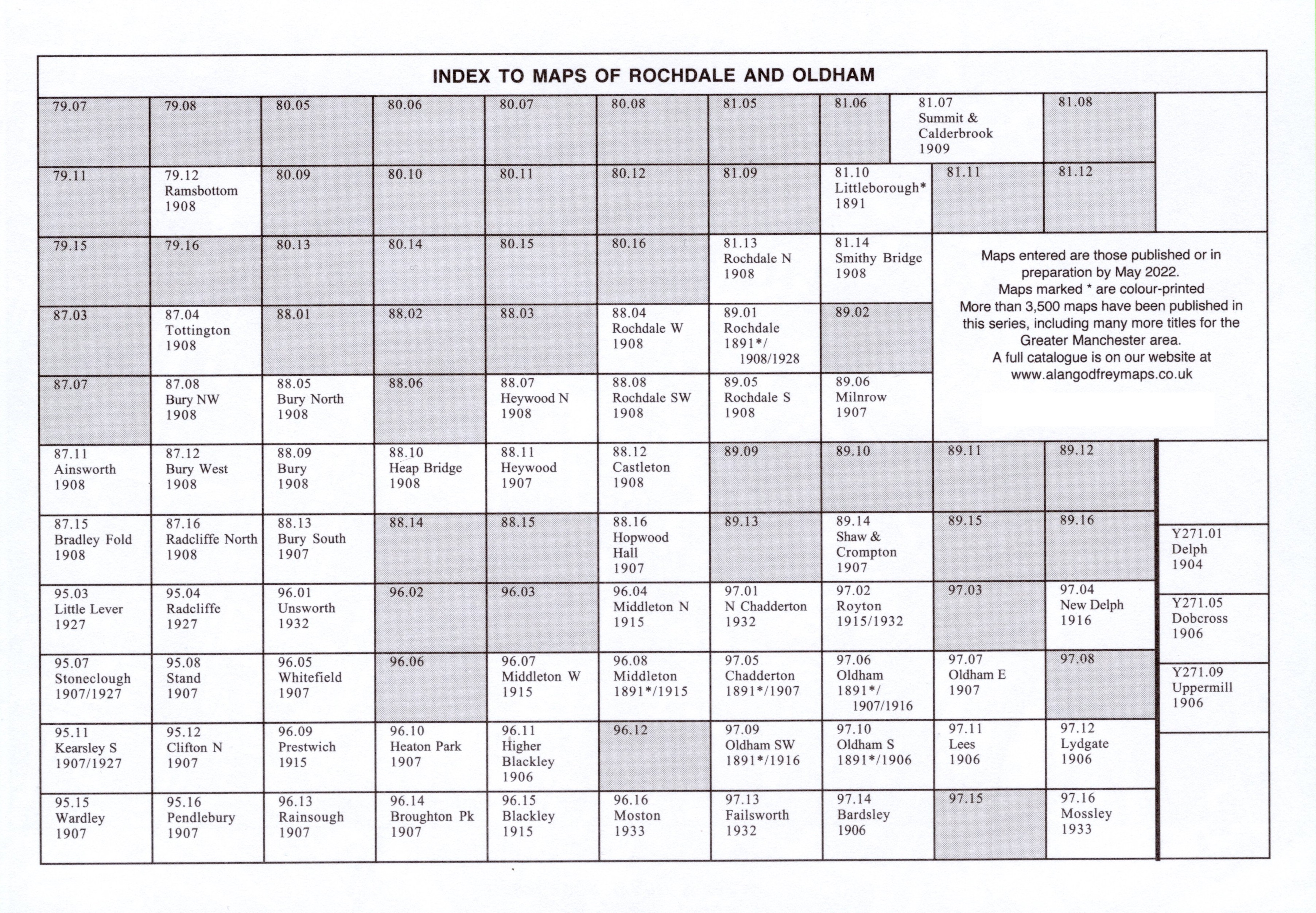
Here is an Index Map for our Rochdale maps.
We also publish a series of smaller scale Inch to the Mile maps. Much of the area is covered by the following maps:
76 Rossendale 1895 - published 2000; intro by Paul Hindle (includes Rochdale and Ramsbottom)
85 Manchester & District 1896 - published 1999; intro by Chris Makepeace (covers Bury and south Rochdale)
For details of this series visit the One Inch page.
 Most maps in the Godfrey Edition are taken from the 25 inch to the mile map and reduced to about 15 inches to the mile.
For a full list of English maps, return to the England page
Most maps in the Godfrey Edition are taken from the 25 inch to the mile map and reduced to about 15 inches to the mile.
For a full list of English maps, return to the England page
Alan Godfrey Maps, Prospect Business Park, Leadgate, Consett, DH8 7PW. Tel 01207 583388
The Godfrey Edition / sales@alangodfreymaps.co.uk / 21 March 2025
 The following Lancashire maps cover the Rochdale MBC area: