Old Ordnance Survey Maps of Bury and Rochdale

  • These detailed maps normally cover an area of about one and a half miles by one mile. Each map includes an introduction.
  • They are available through our On-line Mapshop

  • Here are the details of the map for north Middleton:

  • Lancashire Sheet 96.04 Middleton (North) 1915 - published 2012; intro by Alan Godfrey. ISBN.978-1-84784-607-5

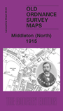
    This very detailed map covers the north of Middleton. Coverage stretches from the Cricket Ground eastward to the railway and from the Old Rectory northward to Stanycliffe.

    Features include Middleton Cricket Ground, Rochdale Road, Rochdale Canal, railway, old Grammar School, Acres, Stanycliffe, tramway, Boarshaw Mill, Irk Vale Chemical Works, Lower Touchethall, Little Green area, Boarshaw area etc. Part of rural Chadderton is also included around Acres. A section of the commercial directory, entries A-O, is included on the reverse.

    The map links up with sheets 96.08 Middleton to the south.


  • Follow this link for a complete list of our Rochdale or Bury maps.
  • You can order maps direct from our On-line Mapshop. For other information and prices, and other areas, go to The Index Page.
  • Maps in the Godfrey Edition are taken from the 25 inch to the mile map and reduced to about 15 inches to the mile. For a full list of maps for the North West, return to the North West page.
    The Godfrey Edition / sales@alangodfreymaps.co.uk / 1 February 2018