
 Here are the details of maps for Greenwich:

We have published three versions of this map, showing how the area developed across the years. The maps each cover the same area, stretching from Deptford Creek eastward to Annandale Road and Selcroft Road, and southward to Vanbrugh House. A portion of Millwall on the Isle of Dogs is also included. Features on the Greenwich side include the Royal Hospital and Royal Naval College, St Alfege's church, Bridge Street, LCDR railway terminus, Maze Hill station, Greenwich Pier, South Metropolitan Gas Works, Bridge Street, Deptford Dry Dock, Thames Street, workhouse and infirmary, Trinity Hospital almshouses, Trafalgar Road with tramways, Christ Church; and coverage extends north to Enderbys Wharf, Chester Street, Telegraph Works, Thames Soap & Candle Works. On the Isle of Dogs coverage includes Napier Shipbuilding Yard, southern part of Millwall Dock, Globe Roap Works, Manchester Road, Wharf Road, Greenwich Vehicular Ferry, Dudgeons Wharf, Plymouth Wharf, Millwall Wharf, much of Cubitt Town. On the 1867 map development of the Isle of Dogs is far from complete.
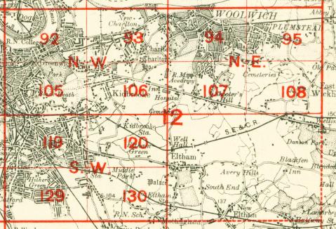
The map links up with London Sheets 79 West India Docks, 91 Deptford to the west, 93 Charlton to the east, 105 Blackheath to the south.
 Follow this link for a complete list of our London maps .