Inch to the Mile Maps of Ireland

  • These Old Ordnance Survey Maps normally cover an area of about 18 miles by 12 miles and are especially good at showing railways, roads and canals, and at giving a broad view of a wider area. Each includes an introduction and a more detailed map of a small town or village. They are available through our On-line Mapshop

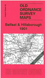
  • Here is information about Sheet 36:

  • Ireland Sheet 36 Belfast & Hillsborough 1901 - published 2009; intro by Alan Godfrey. ISBN.978-1-84784-280-0

    This Inch to the Mile map covers Belfast and the area south and west, including Crumlin, Lisburn, Moira, Hillsborough and (in extreme SW corner) Lurgan.

    The major feature is the city of Belfast, in the NE corner of the map. The map extends westward to Loch Neagh and other features include almost the entire course of the Lagan Navigation, the Great Northern Railway, sections of Lisburn & Banbridge Branch and Belfast & Antrim Jct Branch, Maze Racecourse, etc. On the reverse we include a detailed town plan of Hillsborough, incl Hillsborough Castle, St Malachi's church, Court House, etc.


    It is not possible to list the many hamlets, farmsteads and other topographical features shown on these maps. However, you may find it useful if we list the towns and principal villages or church parishes that are included on this map. Links are given for those for which detailed large-scale maps are also available.

  • Co Antrim: Aghalee, Ballinderry Lower, Belfast, Crumlin, Glenavy, Lisburn, Magheragall, Mazetown.
  • Co Armagh: Lurgan
  • Co Down: Ballymacarret, Belfast, Dollingstown, Drumbo, Hillsborough, Magheralin, Moira, Newtownbreda.
  • An index map is available showing the areas covered by the Inch to the Mile maps. Go to This Index Map.
  • For a full list of maps for One Inch maps for Ireland go to the Ireland Inch to the Mile page; or for other maps of Ireland visit the Ireland page.
  • You can order maps direct from our On-line Mapshop. For other information and prices, and other areas, go to The Index Page.
    Alan Godfrey Maps, Prospect Business Park, Leadgate, Consett, Co Durham, DH8 7PW / sales@alangodfreymaps.co.uk / 16 January 2018