Old Ordnance Survey Maps of Surrey
We have a range of detailed maps for Surrey towns and we also cover the whole county at the Inch to the Mile scale.
Here are the details.
All maps are available from our On-line Mapshop.
Surrey County Council was formed in 1889, when areas close to London, especially Lambeth, Southwark and Wandsworth, were transferred to
the London County Council, and Croydon became a County Borough; and again in 1965 when Croydon, Kingston, Merton, Richmond and Sutton became London Boroughs.
The present Surrey County Council was formed in 1974, with eleven Districts. See This Page for a summary of the county's local government history.
 These are the maps we publish for Surrey:
05.09 Egham 1912 - published 2023; intro by Pamela Taylor
11.06 Chertsey 1912 - published 2020; intro by Tony Painter
11.11 Weybridge (West) & Addlestone 1912 - published 2024; intro by Tony Painter
11.12 Weybridge (East) 1912 - published 2024; intro by Tony Painter
11.15 Weybridge (Brooklands) & Newhaw 1912 - published 2024; intro by Tony Painter
12.03 Hampton Court & East Molesey 1912 - published 2006; intro by Alan Godfrey
12.07 Thames Ditton 1897 - published 2011; intro by Alan Godfrey
12.10 Esher 1912 - published 2023; intro by Tony Painter
13.13 Ewell (West) 1910 - published 2012; intro by Richard Oliver
13.14 Cheam & Ewell 1910 - published 2012; intro by Richard Oliver
15.03 Camberley 1895 - published 2008; intro by Tony Painter
16.14 Brookwood & Pirbright 1895 - published 1998; intro by Alan Godfrey
17.09 Woking 1912 - published 2014; intro by Alan Godfrey
18.15 Leatherhead 1912 - published 2023; intro by Pamela Taylor
19.05 Epsom 1912 - published 2012; intro by Richard Oliver
20.11 Warlingham 1910 - published 1995; intro by Richard Oliver
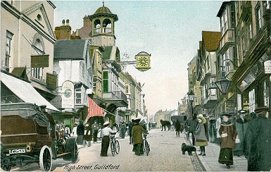
23.16a Guildford 1895 - published 1999; intro by Alan Godfrey
23.16b Guildford 1913 - published 2023; intro by Tony Painter
25.15 Dorking (North) 1913 - published 2024; intro by Tony Painter
26.15 Reigate 1895 - published 2001; intro by Alan A Jackson
26.16 Redhill 1895 - published 2001; intro by Alan A Jackson
30.06 Farnham 1913 - published 2014; intro by Alan Godfrey
31.15 Godalming 1895 - published 2015; intro by Alan Godfrey
33.03 Dorking (South) 1913 - published 2024; intro by Tony Painter
41.04 Horley 1912 - published 2001; intro by Alan A Jackson
The following Middlesex and Buckinghamshire maps cover areas now in Surrey:
Middlesex 19.11 Stanwell 1934 - published 2011; intro by Tony Painter
Middlesex 19.16 Ashford (North) 1934 - published 2012; intro by Tony Painter
Bucks 58.08 Staines 1894 - published 2024; intro by Mike Jee
Go to the London page for individual London boroughs or to the 'Surrey in London' page
for a general list of Surrey sheets within Greater London.
We also cover the whole county in our Inch to the Mile series. Here are the principal maps for the county:
269 Windsor Forest & District 1887 - Published 1998, intro by Christopher Board. Includes a map of Stanwell.
270 South London 1893 - Published 2011, intro by Richard Oliver. Includes a map of Claygate.
285 North West Surrey 1888 - Published 1998, intro by John Griffiths. Includes a map of Worplesdon.
286 East Surrey & Mole Valley 1870 - Published 1998, intro by Richard Oliver. Includes a map of Bletchingley.
301 Haslemere & District 1901 - Published 2003, intro by Tony Painter. Includes a map of Cranleigh.
See the One Inch page for further details of this series.
 Most maps in the Godfrey Edition are taken from the 25 inch to the mile map and reduced to about 15 inches to the mile.
For a full list of English maps, return to the England page
You can order maps direct from our On-line Mapshop.
Most maps in the Godfrey Edition are taken from the 25 inch to the mile map and reduced to about 15 inches to the mile.
For a full list of English maps, return to the England page
You can order maps direct from our On-line Mapshop.
Alan Godfrey Maps, Prospect Business Park, Leadgate, Consett, DH8 7PW. Tel 01207 583388
The Godfrey Edition / sales@alangodfreymaps.co.uk / 17 April 2024
 These are the maps we publish for Surrey: