Old Ordnance Survey Maps of Renfrewshire

  • These detailed maps normally cover an area of about one and a half miles by one mile. Each map includes an introduction.
  • They are available through our On-line Mapshop

  • Here are the details of maps for Renfrew (N):

  • Renfrewshire Sheet 8.07 Renfrew (North) & Yoker 1896 - published 2003; intro by Gilbert Bell. ISBN.978-1-84151-578-6

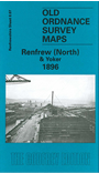
    This detailed map covers the north part of Renfrew, around Meadowside Street, with coverage extending across the Clyde to Yoker.

    Features include Blythswood House, Black Cart Water, Engineering & Shipbuilding Works, London Works, Wharf station, Ferry Road Head, Yoker, Distillery, Lanarkshire & Dumbartonshire Railway, Glasgow Yoker & Clydebank Railway with Yoker station, southern outskirts of Clydebank. On the reverse we include a directory shipbuilders and ship finishers.

    The map links up with Renfrewshire sheet 8.11 Renfrew to the south and Dumbartonshire sheet 25.02 Clydebank to the north.


  • Follow this link for a complete list of our Renfrewshire maps.
  • You can order maps direct from our On-line Mapshop. For other information and prices, and other areas, go to The Index Page.
  • Maps in the Godfrey Edition are taken from the 25 inch to the mile map and reduced to about 15 inches to the mile. For a full list of maps for Scotland, return to the Scotland page.
    The Godfrey Edition / sales@alangodfreymaps.co.uk / 11 November 2016