Old Ordnance Survey Maps of Lancashire

  • These detailed maps normally cover an area of about one and a half miles by one mile. Each map includes an introduction.
  • They are available through our On-line Mapshop

  • Here are the details of maps for Leyland:

  • Lancashire Sheet 69.14 Leyland 1909 - published 2005; intro by David Hunt. ISBN.978-1-84151-743-8

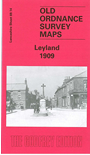
    This detailed map covers the village of Leyland, with coverage stretching from Leyland Bleach Works eastward to Turpin Green, and from Golden Hill Lane southward to Rose Whittle Bridge. Features include Golden Hill, Brook Mills, Brookfield Iron Works, Motor Works, Turpin Green, Heald House Farm, Leyland village with St Andrew's church, Wellington House, Old Hall, stretch of railway, etc. We include a 1918 directory of Leyland on the reverse.

    The map links up with Sheet 69.10 Farington to the north.


    Follow this link for a list of our Lancashire maps.
  • You can order maps direct from our On-line Mapshop. For other information and prices, and other areas, go to The Index Page.
  • Maps in the Godfrey Edition are taken from the 25 inch to the mile map and reduced to about 15 inches to the mile. For a full list of maps for the North West, return to the North West page.
    The Godfrey Edition / sales@alangodfreymaps.co.uk / 17 January 2018