Old Ordnance Survey Maps of Warwickshire
These detailed maps normally cover an area of about one and a half miles by one mile. Each map includes an introduction.
They are available through our On-line Mapshop
 Here are the details of maps for Yardley Wood:
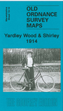
Warwickshire Sheet 19.10 Yardley Wood & Shirley 1914 - published 2007; intro by Barrie Trinder. ISBN.978-1-84784-066-0 
This detailed map covers a semi-rural area south of Birmingham, including the hamlet of Solihull Lodge, Warstock and parts of Yardley Wood and Shirley. Christ
Church Yardley Wood is at the top of the map and coverage extends south to Peterbrook Road. The Stratford on Avon Canal runs through the map. The GWR North
Warwickshire line also runs through, including Shirley station. Other features include Hazeluck's Green, Hazeloak Farm, Colebrook Priory. A directory of Shirley in
1921 is included on the reverse.
For a full list of maps of Warwickshire, please go to the Warwickshire or Birmingham pages.
You can order maps direct from our On-line Mapshop.
For other information and prices, and other areas, go to The Index Page.
Maps in the Godfrey Edition are taken from the 25 inch to the mile map and reduced to about 15 inches to the mile.
For a full list of maps for England, return to the England page.
Alan Godfrey Maps, Prospect Business Park, Leadgate, Consett, Co Durham, DH8 7PW / sales@alangodfreymaps.co.uk / 23 November 2017