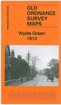
Warwickshire Sheet 8.03 Wylde Green 1913 - published 2013; intro by Roger Lea. ISBN.978-1-84784-677-8 
This detailed map covers the area between Sutton Coldfield and Erdington, stretching from While Road southward to Wylde Green station. Features include LNWR railway with Wylde Green station, stretch of Midland Railway Walsall & Water Orton line,
New Hall, Newhall Mill, Wylde Green House, Maney area, Wylde Green area, St Peter's church Maney, Driffold, Maney House, Maney Hill, Horse & Jockey Hotel etc. We include a 1921 directory of Wylde Green on the reverse.
The map links up with sheet 4.15 Sutton Coldfield to the north and 8.07 Erdington Chester Rd to the south.
For a full list of maps of Warwickshire, please go to the Birmingham page or (for areas outside Birmingham) to the Warwickshire page.
You can order maps direct from our On-line Mapshop.
For other information and prices, and other areas, go to The Index Page.
Maps in the Godfrey Edition are taken from the 25 inch to the mile map and reduced to about 15 inches to the mile.
For a full list of maps for England, return to the England page.
Alan Godfrey Maps, Prospect Business Park, Leadgate, Consett, Co Durham, DH8 7PW / sales@alangodfreymaps.co.uk / 18 January 2018
 Here are the details of maps for Wylde Green: