
 Here are the details of maps for Omagh:

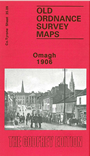
This detailed map gives very good coverage of the attractive Co Tyrone town of Omagh. The sheetlines are quite kind and most of the town is shown, with coverage eastward to Tyrone County Hospital.
Features include High Street, Market Street, John Street, Church Street, Campsie Road, all with individual buildings neatly delineated. Court House, Fair Green, Corn Market, RC church, Presbyterian church, Infantry Barracks, County Hospital, Creevenagh House, Campsie Saw Mills, Lisnamallard Mills, Lisnamallard House, Riverdale, Old Barracks; railway with station, goods shed, engine house, Market Goods station and branch, all clearly shown with track layout. Meetinghousehill area, Dergmoney Lower area, Gortmore House, Coolnagard Lower area, etc. On the reverse we include extracts from a street directory, including Abbey Street, Campsie Avenue, Campsie Road, Castle Street, Church Street, Dublin Road, George's Street, High Street, John Street, Market Street, Mountjoy Road.