
 Here are the details of maps for Dawley & Horsehay:

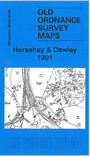
This detailed map covers the area of Telford around Horsehay, with coverage extending eastward to Dawley High Street, and westward to Coalmoor. Features include Horsehay Pool, Bridge & Roof Works, Foresters Arms, Horsehay Dingle, Prospect House, Coalmoor Farm, Doseley, St Luke's church, Coalmoor Colliery, Poolhill, Brandlee, Dawley High Street, Deepfield Colliery. The GWR line runs through the map with Horsehay station. We also include a directory for Dawley Magna and a railway timetable for the Wellington-Craven Arms line.
The map links up with sheets 43.02 Lawley to the north, 43.07 Dawley Magna to the east and 43.10 Coalbrookdale to the south.