Old Ordnance Survey Maps of Renfrewshire

  • These detailed maps normally cover an area of about one and a half miles by one mile. Each map includes an introduction.
  • They are available through our On-line Mapshop

  • Here are the details of maps for Gourock:

  • Renfrewshire Sheet 01.04 Gourock 1912 - published 2008; intro by Gilbert Bell. ISBN.978-1-84784-136-0

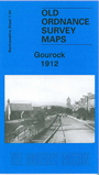
    This detailed map covers the town of Gourock, jutting out on the Forth of Clyde, and the terminus of the Caledonian Railway's Gourock Branch. Most of the town is covered (although the nature of the sheetlines do give rather a lot of sea on this map!) Features include the station, railway approaches and turntable, Barr Hill, Craigsmuschet Quarry, Kempock Point, churches, tramways, Tower Hill, Kempock Stone, Ironotter Point, Cardwell Bay, Public Park, and the town centre with houses neatly delineated. On the reverse we include a selection of trade directory entries.


  • Follow this link for a complete list of our Renfrewshire maps.
  • You can order maps direct from our On-line Mapshop. For other information and prices, and other areas, go to The Index Page.
  • Maps in the Godfrey Edition are taken from the 25 inch to the mile map and reduced to about 15 inches to the mile. For a full list of maps for Scotland, return to the Scotland page.
    The Godfrey Edition / sales@alangodfreymaps.co.uk / 11 November 2016