Old Ordnance Survey Maps of Lincolnshire
This page summarises the local government organisation of Lincolnshire since 1894.
 Following local government organisation in 1889 the geographical county of Lincolnshire was governed by 3 County Councils and 2 County Boroughs, Lincoln and
Great Grimsby. The County Councils, established in 1889, were:
Following local government organisation in 1889 the geographical county of Lincolnshire was governed by 3 County Councils and 2 County Boroughs, Lincoln and
Great Grimsby. The County Councils, established in 1889, were:
Holland, comprising Boston Municipal Borough, Holbeach Urban District, Long Sutton Urban District, Spalding Urban District, and Sutton Bridge Urban District, plus Boston, Crowland, East Elloe, and Spalding Rural Districts.
Most of these districts were abolished and merged in 1932, leaving Boston MB, Spalding UD, and East Elloe RD. The county office was in Boston but the council met alternately at Boston or Spalding.
Kesteven, comprising Grantham Municipal Borough, Stamford Municipal Borough, Bourne Urban District, Bracebridge Urban District, Ruskington Urban District, and Sleaford Urban District, plus Bourne, Branston, Claypole, Grantham, Sleaford
and Uffington Rural Districts. Bracebridge UD was abolished in 1920 and Ruskington in 1931, and in 1931 the rural districts were merged into four: North, West, East and South Kesteven. The county council met alternately at Grantham or Sleaford.
Lindsey, comprising Alford Urban District, Barton-on-Humber Urban District, Brigg Urban District, Broughton Urban District (absorbed by Roxby in 1923), Brumby & Frodingham Urban District (until 1919),
Cleethorpes with Thruncoe Urban District (Cleethorpes UD from 1916), Crowle Urban District (absorbed by Isle of Axholme RDC in 1936), Gainsborough Urban District, Horncastle Urban District, Louth Urban District,
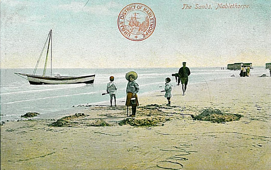
Mablethorpe Urban District (Mablethorpe & Sutton UD from 1925), Market Rasen Urban District, Roxby cum Risby Urban District (until 1936), Scunthorpe Urban District (Scunthorpe, Brumby & Frodingham UD from 1919), Skegness Urban District, Winterton Urban District (until 1936), and Woodhall Spa Urban District; plus Caistor, Gainsborough, Glanford Brigg, Grimsby, Horncastle, Isle of Axholme,
Louth, Spilsby, and Welton Rural Districts. In 1936 Sibsey RD and Spilsby RD were merged. Cleethorpes and Scunthorpe became Municipal Boroughs in 1936. Lincoln and Grimsby, within Lindsey geographical county, were County Boroughs. The council met at Lincoln.
In 1974 these authorities were abolished. The northern part of Lindsey became part of the new county of Humberside, while the rest of the county became the non-metropolitan county of Lincolnshire.
The Humberside area comprised the former Grimsby County Borough, Cleethorpes and Scunthorpe Municipal Boroughs, Barton and Brigg Urban Districts, and
Glanford Brigg, Grimsby, and Isle of Axholme Rural Districts. The new county had nine Districts, of which four were in Lincolnshire: Cleethorpes, Glanford, Grimsby (later renamed Great Grimsby), and Scunthorpe.
However, the county of Humberside was abolished in 1996 and its Lincolnshire area was divided into two unitary authorities, North Lincolnshire (centred on Scunthorpe) and
North East Lincolnshire (based on Grimsby).
The remainder of Lincolnshire became a new non-metropolitan county in 1974, comprising seven Districts: Boston, East Lindsey, Lincoln, North Kesteven, South Holland, South Kesteven, West Lindsey.
For a list of our Lincolnshire maps go to the main Lincolnshire page.
Most maps in the Godfrey Edition are taken from the 25 inch to the mile map and reduced to about 15 inches to the mile.
They cost just £ 3.00 each (Coloured editions £ 4.00). For a full list of English maps, return to the England page
You can order maps direct from our On-line Mapshop.
Minor changes are not listed here, but please advise us of any significant errors or omissions.
Alan Godfrey Maps, Prospect Business Park, Leadgate, Consett, DH8 7PW. Tel 01207 583388
The Godfrey Edition / sales@alangodfreymaps.co.uk / 25 November 2016
 Following local government organisation in 1889 the geographical county of Lincolnshire was governed by 3 County Councils and 2 County Boroughs, Lincoln and
Great Grimsby. The County Councils, established in 1889, were:
Following local government organisation in 1889 the geographical county of Lincolnshire was governed by 3 County Councils and 2 County Boroughs, Lincoln and
Great Grimsby. The County Councils, established in 1889, were: