Old Ordnance Survey Maps of Leeds


  • For the central area of Leeds we have reprinted some of the very early Five-foot plans. Originally published at a scale of 1:1056 or 5 feet to the mile, we have reduced them in scale to 1:1760 or a Yard to the Mile. The maps, though covering quite a small area, are wonderfully detailed, showing such features as capstans and mooring posts, lamp-posts, the layouts of back yards, and even the interior of certain buildings such as churches. For the urban historian they are perhaps the most fascinating maps ever published by the Ordnance Survey.
  • Each map includes a specially written introduction to the area. Maps can be purchased on our On-line Mapshop where further information about titles is given.

  • Here are the details of maps for Holbeck:

  • Leeds 18 Holbeck 1847 - published 2024; intro by Alan Godfrey. ISBN.978-1-78721-776-8

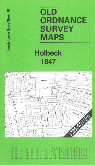
    This very detailed map covers a major part of Holbeck with a smaller area of Hunslet.

    Features include Benyon's Mill, Meadow Lane Pottery, Marshall's Mill, Independent Chapel, Marshall's School, Benyon Beck, St Matthew's Church, Isle Lane Chapel, Wesleyan Association Chapel, Holbeck Mill, Union Mill, Low Hall Mill, Stocks Hill, Low Beck, Leeds & Bradford (later Midland) railway.

    On the reverse we include a 1:500 map showing part of the area in 1889.

    The map links up with Sheets 11 Leeds Headrow to the west.


  • Follow this link for a complete list of our Leeds maps. For other information and prices, and other areas, go to The Index Page.
  • This map is taken from the OS '60 Inches to the Mile' map and reduced to a scale of '36 Inches to the Mile' For a full list of maps for England, return to the England page.
    Alan Godfrey Maps, Prospect Business Park, Leadgate, Consett, Co Durham, DH8 7PW / sales@alangodfreymaps.co.uk / 24 July 2024