 Here are the details of maps for Bolton NE:

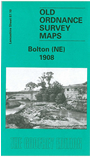
This detailed map covers the north east outskirts of Bolton, with coverage stretching from Turner Bridge (SW corner of map) eastward to Harwood (NE corner). Although still a semi rural landscape, there is much of interest and features include Turner Bridge Mill, Mill Hill Bleach Works, tramways, Eastfield Farm, Bradshaw Brook, Undershore Bleach Works, Thicketford Bridge, Firwood Bleach Works, Firwood Fold, Harwood, Christ Church, Breightmet Hill West and East. On the reverse we include street directory entries for Ainsworth Lane, Eldon Street, Horsa Street, Moorfield Grove, Thicketford Road, Tonge Moor Road.
The map links up with Lancashire Sheets 87.06 Bradshaw to the north, 87.09 Bolton North to the west, 87.11 Ainsworth to the east and 87.14 Bolton East to the south.