 Here is information about Sheet 44:
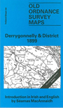
This Inch to the Mile map covers part of SW Fermanagh, with a smaller section of Co Leitrim. Coverage stretches from Garrison and the eastern end of Lough Melvin, eastward to Rossclare Bay on Lough Erne, and from Drumreask and Church Hill southward to Belcoo. Features include part of Lower Lough Erne, Lough Macnean Upper, a stretch of the Sligo Leitrim & Northern Counties Railway, Belmore Mountain, Tullybrack etc.
On the reverse we include a detailed village plan for Derrygonnelly, showing the houses lined along the main (only) street; also St Michael's RC chapel, Fair Green, ruined church, creamery, plus a short directory of the village. The introduction by Séamas Mac Annaidh is in both English and Irish.
It is not possible to list the many hamlets, farmsteads and other topographical features shown on these maps. However, you may find it useful if we list the towns and principal villages or church parishes that are included on this map. Links are given for those for which detailed large-scale maps are also available.