Old Ordnance Survey Maps of Norfolk

  • These detailed maps normally cover an area of about one and a half miles by one mile. Each map includes an introduction.
  • They are available through our On-line Mapshop

  • Here are the details of maps for Diss:

  • Norfolk Sheet 110.02 Diss 1903 - published 2002; introduction by Robert Malster. ISBN 1-84151-373-3

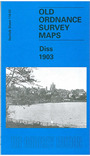
    This detailed map gives good coverage of the south Norfolk town of Diss, with coverage stretching south to the county border; a small portion of this map is Suffolk Sheet 25.02. Features on the map include the town centre, brewery, Market Place, St Mary's church, The Mere; with coverage continuing SW to Denmark Green and Denmark Bridge; SE along Victoria Road and to station and isolation hospital; north to Mount Street Road, matting factories and Walcot Hall. A directory of Diss in 1900 is included on the reverse.


  • Follow this link for a complete list of our Norfolk or Suffolk map; or for a full list of maps for East Anglia, go to the East Anglia page.
  • Most maps in the Godfrey Edition are taken from the 25 inch to the mile map and reduced to about 15 inches to the mile. You can order maps direct from our On-line Mapshop. For other information and Prices, see Index Page.
    The Godfrey Edition / sales@alangodfreymaps.co.uk / 28 January 2018