Bad Sellers
ALAN GODFREY MAPSHOP | Bad Sellers
Page: << < 1 2 3 > >> View All (30) Page: << < 1 2 3 > >> View All (30)ALAN GODFREY MAPSHOP | Bad Sellers
New Products
Ed 33 Edinburgh Wester Coates 1878
Large scale plan of Wester Coates; Edinburgh sheet 33
Introduction by Alan Godfrey
Reduced from the 5' plan to 'A Yard to the Mile'
Beautifully detailed map of small area
Covers Donaldson's Hospital, Roseburn Free Church, West Coates Church, John Watson's Institution, Haymarket Mills and Stone Depot.
find out more
La 88.06 Bury (East) 1928
Detailed map of Bury (East); Lancashire sheet 88.06
Introduction by Nigel Jepson
Covers Bury Union Institution, Woodgate Hill, Fairfield, Jericho, Castle Hill Quarry, Fern Grove Mills, Wagon & Horses Public House, Delph House and Broad Oak Farm.
find out more
Nt 34.03 Southwell 1899
Detailed map of Southwell; Notts sheet 34.03
Historical introduction by Barrie Trinder
Covers Holy Trinity Church, Westhorpe, The Hall, Normanton Prebend House, St Mary's Minster and Norwood House.
find out more
Nt 42.03 Nottingham (East) & Colwick Park 1913
Detailed map of Nottingham (East); Notts sheet 42.03
Historical introduction by Barrie Trinder
Covers St Clements Church, Swinton Dale Farm, Colwick House, Thorneywood Station, Colwick Crossing, Carlton Brick Works and Carlton House.
find out more
Subscription: Next 10 maps of Cambridge & District
Subscription to next 10 Maps of Cambridge & District
You will receive the next 10 Cambridge & District maps as they are published. Excellent value at £27.50 until 26th September (£33.00 thereafter)
Commences November
UK ADDRESSES ONLY
find out more
LS 7.03 Metropolitan Cattle Market 1871-94
Large Scale Plan of Metroplitan Cattle Market; London sheet 7.03
Introduction by Pamela Taylor
Covers St Paul's Church, English Presbyterian Church, Metropolitan Cattle Market and Camden Road, Brecknock Road, Hartham Road Area.
find out more
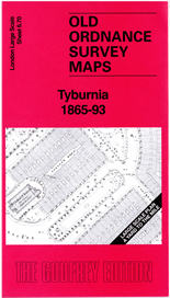
LS 6.70 Tyburnia 1865-93
Large Scale Plan of Tyburnia;
London sheet 6.70
Introduction by Pamela Taylor
Covers Hyde Park Square, St John's Church, Norfolk Square Hotel, St George Hanover Square, National School and London and County Bank.
find out more
Nn 35.12 Braunston 1899
Detailed map of Braunston; Northants sheet 35.12
Historical introduction by Barrie Trinder
Covers All Saint's Church, Manor House, Butcher's Bridge, Railway Station, Little Braunston, Wheatsheaf Inn and Braunston Wharf.
find out more
Nn 19.05 Oundle 1899
Detailed map of Oundle; Northants sheet 19.05
Historical introduction by Barrie Trinder
Covers Anchor Brewery, Town Hall, Laundimer House, St Peter's Church, Jesus Church, Half Moon Inn and South Bridge.
find out more
Yls 09 York The Minster & Bootham Bar 1851
Large Scale map of The Minster & Bootham Bar. York Large Scale Sheet 9
Introduction by Alan Godfrey
Covers St Helen's Church, Salem Chapel, Layerthorpe Bridge, Yorkshire Yeoman School, St Maurice's Church, County Hospital and Gas Works.
find out more
Yls 08 York Marygate 1851
Large Scale map of York Marygate. York Large Scale Sheet 8
Introduction by Alan Godfrey
Covers Ragged School, Museum of the Yorkshire Philosophical Society, Yorkshire School for the Blind, St Olave's Church, The Museum Gardens and Wandesfords Hospital.
find out more
Ndn 86.12 Monkseaton 1914
Detailed map of Monkseaton; Northumberland sheet 86.12
Historical introduction by Anthea Lang
Covers St Paul's Church, Monkseaton Station, Whitley Quarry, St Edward's Church, Northumberland Square, Newsteads Farm and Northumberland Village Homes.
find out more


