'Garages or Depôts, Part 2'
Correspondence
 We received several emails about the piece about Garages and Depots
in the last Newsletter, perhaps inevitably suggesting regional variations.
One correspondent, F.K., wrote that "Local authorities had started to run
bus services pre-WW1 but now numbers increased while bus companies, viz. United, developed large fleets through the 1920s/1930s. This is where names
change. United stuck rigidly to 'depots'. Newcastle Corporation had operated trams and started bus services in this period. They held on to 'depots'
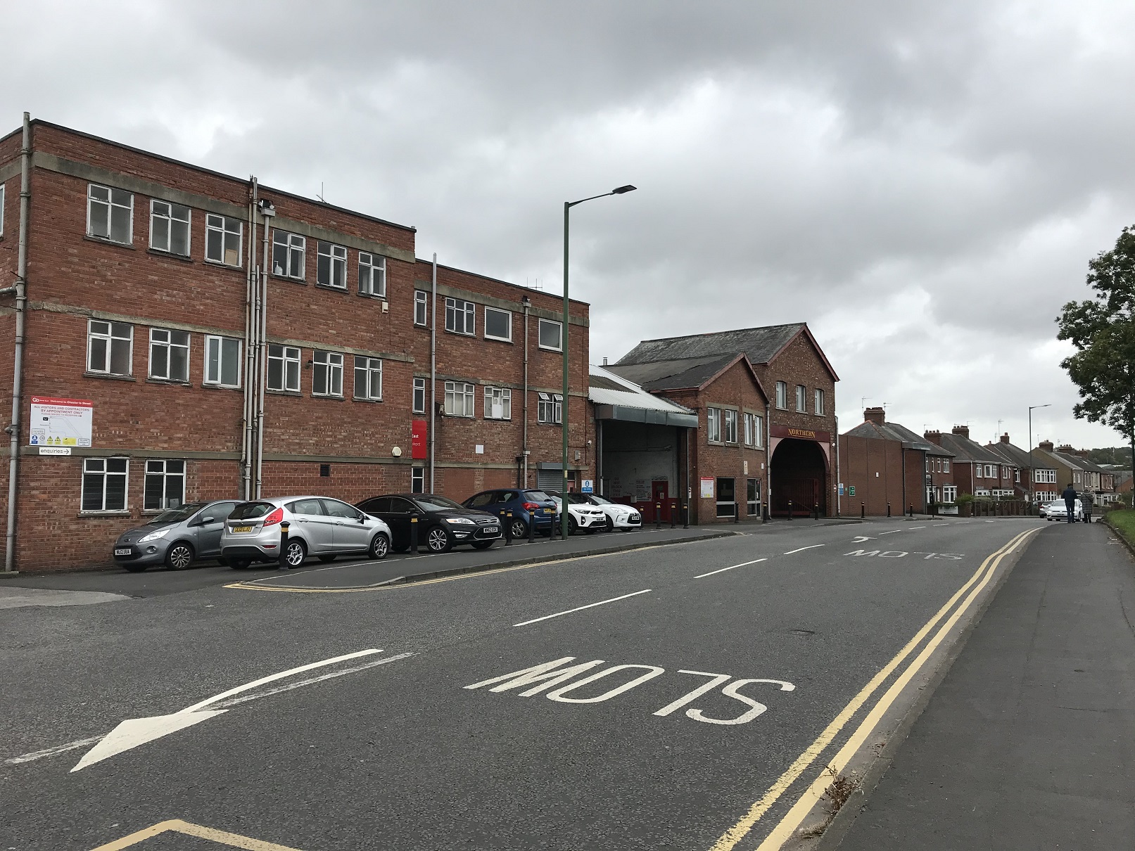
and that term has continued into Stagecoach current operation. It has always been 'Byker Depot'. Northern General goes back to 1913 when Gateshead &
District Tramways were asked to provide a bus service to Chester-le-Street (depot, picture left). 'Depot' was retained as operation expanded and the 'Northern' name
appeared...Where trams continued they were still housed in depots but new premises became garages until 'depot' ceased to be used at all - in
official circles". At Stockport the new Daw Bank garage was built but staff still tended to talk about 'the depot' and that was common".
We received several emails about the piece about Garages and Depots
in the last Newsletter, perhaps inevitably suggesting regional variations.
One correspondent, F.K., wrote that "Local authorities had started to run
bus services pre-WW1 but now numbers increased while bus companies, viz. United, developed large fleets through the 1920s/1930s. This is where names
change. United stuck rigidly to 'depots'. Newcastle Corporation had operated trams and started bus services in this period. They held on to 'depots'
and that term has continued into Stagecoach current operation. It has always been 'Byker Depot'. Northern General goes back to 1913 when Gateshead &
District Tramways were asked to provide a bus service to Chester-le-Street (depot, picture left). 'Depot' was retained as operation expanded and the 'Northern' name
appeared...Where trams continued they were still housed in depots but new premises became garages until 'depot' ceased to be used at all - in
official circles". At Stockport the new Daw Bank garage was built but staff still tended to talk about 'the depot' and that was common".
My old friend 'Sam Slide' from Buxton wrote that "In my area the Dearne District Light Railway, a tramway system running south-east from Barnsley,
was I think unique in the UK in using the US term 'Car Barn' for their depot. I know we don't always approve of Americanisms - but in this case it
is a good description of the scale and construction of the building. I worked in the area about twenty years ago; a newer garage building large
enough for double-deckers was still in use on the same site. This was to the west of Brampton, between Wombwell and Wath. It was replaced by housing
a few years ago. I don't think the light railway/tramway was a great success. With a long route meandering through the Dearne Valley's mining towns
and villages, it must have been a slow ride!"
From the East Midlands T.O. brought European references, perhaps sensing my nostalgia for trolley-buses: "You'd probably like Vilnius in Lithuania!
Unlike the other cities in the Baltic States, it has trolley buses rather than trams. Personally I prefer trams, but my Dad, who worked at Duple
coach builders in Hendon, London, preferred trolley buses. During WW2, Duple made parts for the Halifax bomber which was put together at other
factories in London. I was born on the day President Roosevelt died, so was just old enough to remember the last week of London's trams - sob!
However I do like the modern generation of trams, particularly those in Nottingham".
Like all good map-lovers he then digresses, "I enjoy following the old tram and railway lines on those of your maps in my collection. Right in the middle of the
Kirkby-in-Ashfield map (Notts sheet 27.11) is an incredibly complex jumble of railways all competing with each other for the coal from Kirkby
(also known as Summit) Colliery. The extensive sidings to handle the coal wagons went long ago, and all that can be seen...is greenery,
trees and a playing field. Also gone is Kirkby Railway Station and its level crossing over the main road. After extensive modifications to the
railways by Nottinghamshire County Council to build the Robin Hood Line between Nottingham - Mansfield - Worksop, a new Kirkby Station was built
immediately north of the bridge where the Leen Valley Extensions passes under Lane End. Both the Railway Inn and the cinema are long gone and have
been replaced by an attractive modern Aldi store of which I'm sure, Le Corbusier would be proud. On the left half of the map is a 'Railway in course
of construction' which provided Kirkby with another station; Beeching closed that one as well! The Police Station mentioned at the end of Barry
Trinder's introduction is now located in the new Ashfield District Council Offices built close to where the Kirkby Station on Urban Street used to
be. The older Urban District Council Offices built in 1933 still exist but as private offices and has been renamed Ada Lovelace House after Lord
Byron's daughter. I don’t think Ada Lovelace had any connection with the building, but it does house a computer company". (I might add that several
European cities retain trolley-buses, and you can find a complete list online, but do any have double-deck trolley-buses, where you can (could) hear
the clatter of the wires right over your head? That apart, my recommendation would be Wuppertal, where you can ride on the wonderful Schwebebahn
(or Suspension Railway) and then get a trolley bus on to Solingen. AG)
There were less theories as to the difference between a cinema and picture theatre in OS terms. But our author Anthea Lang notes, rather
tentatively I think, that "A picture theatre was somewhere where live entertainment was common but also showed moving pictures. As films became more
popular and purpose-built buildings were erected, they were known as cinemas from the Greek kinema (movement) (hence the name Kino often given to
early cinemas) and also reduced from the French cinematographe. Early cinemas often did have live performances but the difference is they
did not use an existing building - as was usually the case with a picture theatre. The latter also did not usually have raked seating which was a
feature of cinemas". Hmm. I think there is room for more research on this one, as Anthea suspects, ending her email with "I can sense the vibes of
doubt from your end!"
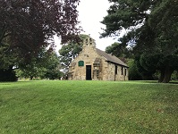
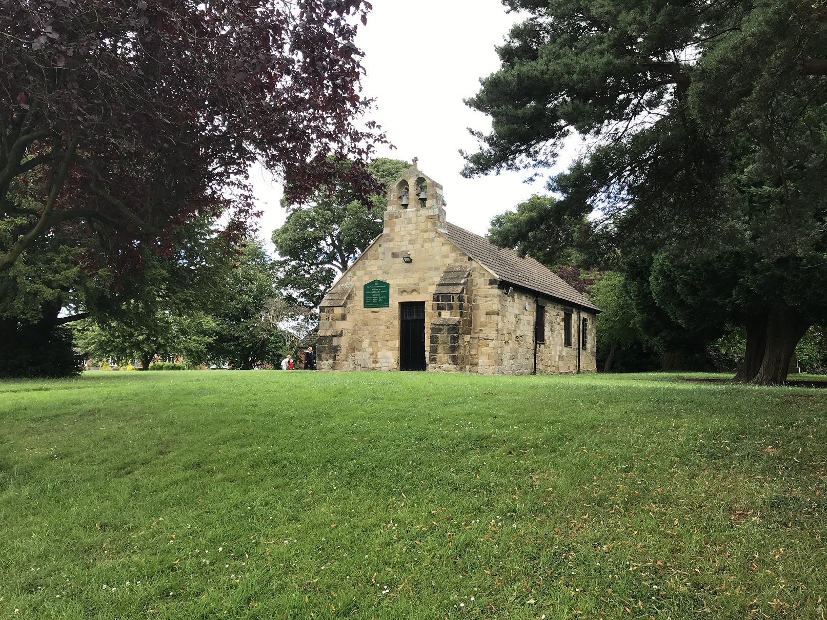
 Of course, it is these little touches that make the study of Ordnance Survey maps so fascinating. I was recently walking round Thornaby-on-Tees, preparatory
to writing about the town, and came to the medieval church of St Peter ad Vincula, set delightfully on The Green. The tiny church is still in use and by happy chance
the vicar was emerging - and offered to show me round. This was most enjoyable and before parting we walked round the back, where he pointed out an obscure inscription,
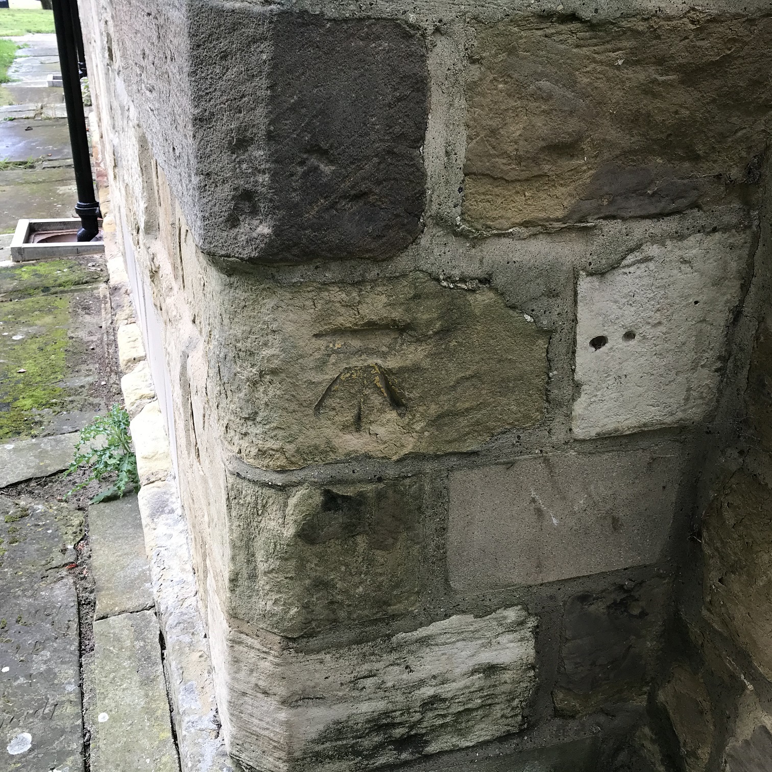
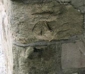
perhaps hoping that it was medieval. I think he was quite disappointed when I corrected him, saying that it was an OS benchmark (see pictures).
Of course, it is these little touches that make the study of Ordnance Survey maps so fascinating. I was recently walking round Thornaby-on-Tees, preparatory
to writing about the town, and came to the medieval church of St Peter ad Vincula, set delightfully on The Green. The tiny church is still in use and by happy chance
the vicar was emerging - and offered to show me round. This was most enjoyable and before parting we walked round the back, where he pointed out an obscure inscription,
perhaps hoping that it was medieval. I think he was quite disappointed when I corrected him, saying that it was an OS benchmark (see pictures).
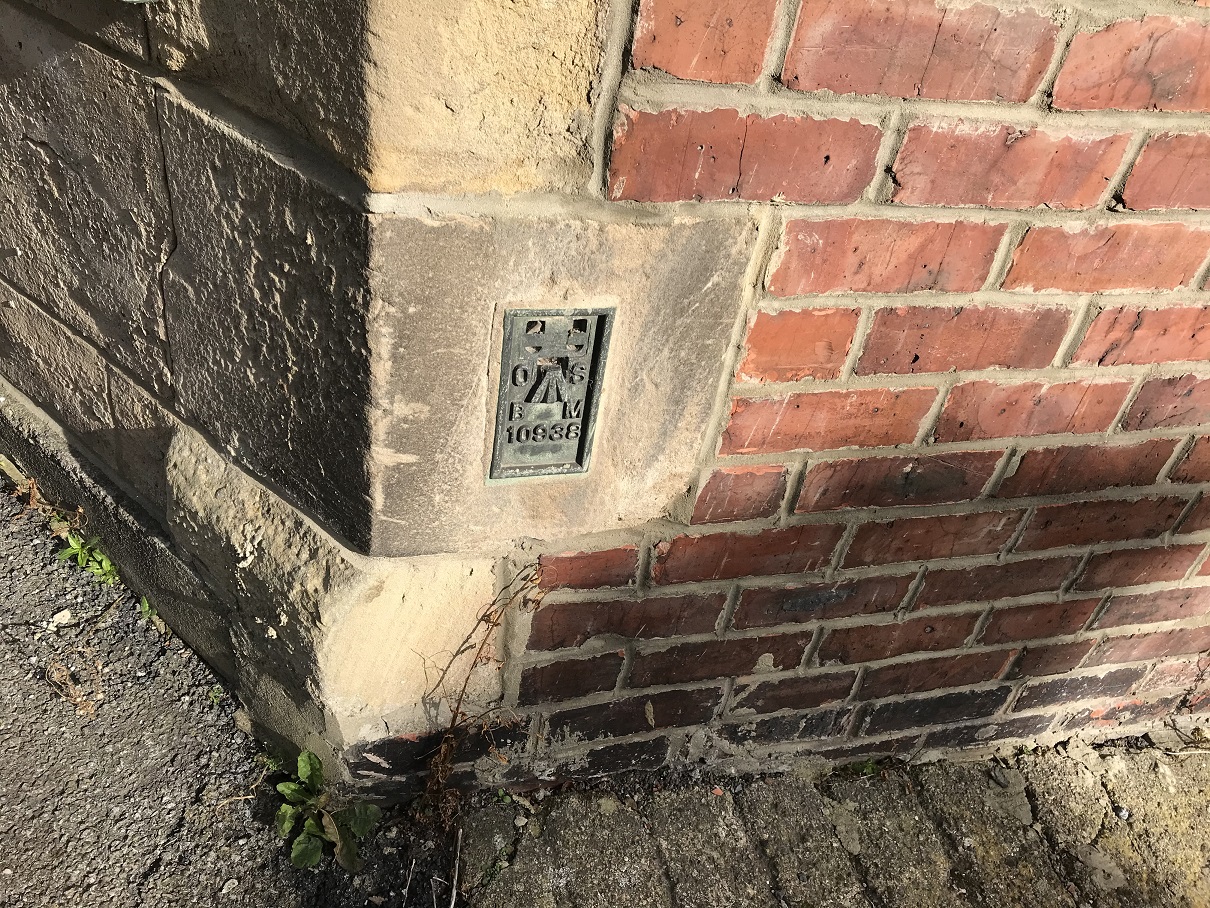
 Benchmarks, a horizontal line with a broad arrow below, were
used by the OS to mark the height 'relative to Ordnance Datum' and can be used as a reference point
for further mapping. They are marked as B.M. on maps, with the height given alongside. They are no longer maintained and, of course, many have disappeared
through demolition or erosion (and some have been moved, or rendered inaccurate through mining subsidence). They are to be cherished, and I often feel that
they are something of an Ordnance Survey signature, "The OS has been here!". Perhaps walk round the map of your own area and see how many survive.
19th century ones tend to be carved onto stone, on a wall or building that was expected to survive,
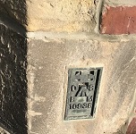
but later ones were metal and I am delighted to say that the terrace where I live has one - but presumably added quite late, as it is not recorded
on even the 1939 revision map - or is there another reason for its non-appearance on the map? (see pic right).
Benchmarks, a horizontal line with a broad arrow below, were
used by the OS to mark the height 'relative to Ordnance Datum' and can be used as a reference point
for further mapping. They are marked as B.M. on maps, with the height given alongside. They are no longer maintained and, of course, many have disappeared
through demolition or erosion (and some have been moved, or rendered inaccurate through mining subsidence). They are to be cherished, and I often feel that
they are something of an Ordnance Survey signature, "The OS has been here!". Perhaps walk round the map of your own area and see how many survive.
19th century ones tend to be carved onto stone, on a wall or building that was expected to survive,
but later ones were metal and I am delighted to say that the terrace where I live has one - but presumably added quite late, as it is not recorded
on even the 1939 revision map - or is there another reason for its non-appearance on the map? (see pic right).
It is always good to hear from you of your experience and use of maps. Unless you say otherwise we will presume we can quote your letters but will just
initialise your name.
Alan Godfrey Maps, Prospect Business Park, Leadgate, Consett, Co Durham, DH8 7PW / sales@alangodfreymaps.co.uk / 2 May 2020
 We received several emails about the piece about Garages and Depots
in the last Newsletter, perhaps inevitably suggesting regional variations.
One correspondent, F.K., wrote that "Local authorities had started to run
bus services pre-WW1 but now numbers increased while bus companies, viz. United, developed large fleets through the 1920s/1930s. This is where names
change. United stuck rigidly to 'depots'. Newcastle Corporation had operated trams and started bus services in this period. They held on to 'depots'
and that term has continued into Stagecoach current operation. It has always been 'Byker Depot'. Northern General goes back to 1913 when Gateshead &
District Tramways were asked to provide a bus service to Chester-le-Street (depot, picture left). 'Depot' was retained as operation expanded and the 'Northern' name
appeared...Where trams continued they were still housed in depots but new premises became garages until 'depot' ceased to be used at all - in
official circles". At Stockport the new Daw Bank garage was built but staff still tended to talk about 'the depot' and that was common".
We received several emails about the piece about Garages and Depots
in the last Newsletter, perhaps inevitably suggesting regional variations.
One correspondent, F.K., wrote that "Local authorities had started to run
bus services pre-WW1 but now numbers increased while bus companies, viz. United, developed large fleets through the 1920s/1930s. This is where names
change. United stuck rigidly to 'depots'. Newcastle Corporation had operated trams and started bus services in this period. They held on to 'depots'
and that term has continued into Stagecoach current operation. It has always been 'Byker Depot'. Northern General goes back to 1913 when Gateshead &
District Tramways were asked to provide a bus service to Chester-le-Street (depot, picture left). 'Depot' was retained as operation expanded and the 'Northern' name
appeared...Where trams continued they were still housed in depots but new premises became garages until 'depot' ceased to be used at all - in
official circles". At Stockport the new Daw Bank garage was built but staff still tended to talk about 'the depot' and that was common".