
 Here are the details of maps for the City and Whitechapel:

We have published three versions of this map, showing how the area developed across the years. The maps each cover the same area, a major area of central London, covering much of The City and extending across Whitechapel, Bishopsgate and Spitalfields. The area covered runs from Moorgate eastward to Bedford Street, and fromWorship Street and Quaker Streetr southward to The Tower. The many features include The Bank of England, the northern part of The Tower; Broad Street, Liverpool Street, Moorgate, Fenchurch Street, Cannon Street, Bishopsgate stations; Royal Mint, Custom House, London Hospital, Aldgate; streets include Cornhill, Threadneedle Street, Finsbury Pavement, Whitechapel Street, Whitechapel Road, Commercial Road, Leman Street and countless more; many City churches and their parishes are shown, and also St George in the East, Christ Church Spitalfields. A mass of detail on all three maps, and fascinating to everyone interested in the history of London.
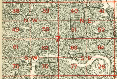
The map links up with London Sheets 51 Shoreditch to the north, 62 Holborn to the west, 64 Stepney to the east, 77 Bermondsey to the south.
 Follow this link for a complete list of our London maps .