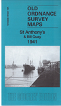
 Here are the details of maps for St Anthonys & Bill Quay:
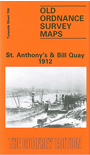

We have published two versions of this map, showing how the area changed across the years.
These detailed maps cover the St Anthony's area and part of Walker north of the Tyne, and parts of Felling and Hebburn to the south. Features N of the river include St Anthony's church, Walker Park, Riverside Branch railway and various shipyards and works by the river. S of the Tyne we have Bill Quay, Pelaw MainTyne Copper Works, Deans Primrose Staith, Maloney's Quay, Pelaw Main Staith, LNER South Shields Branch and various works.
The map links up with Tyneside Sheet 13 Walker & Hebburn to the north, Tyneside Sheet 19 Gateshead East to the south, 20 Monkton to the south and Durham Sheet 7.02 Heworth to the south.
Maps in the Godfrey Edition are taken from the 25 inch to the mile map and reduced to about 15 inches to the mile. For a full list of maps for the North East, return to the North East page.
The Godfrey Edition / sales@alangodfreymaps.co.uk / 27 October 2016