
 The Fylde can be a cruel awakening. In the January of ‘54 a diminutive child of 10 was seen to Euston station, put on a train by his father and despatched north. From the gentle valleys of Wiltshire to the factory fumes of Warrington and coal hills of Wigan was journey enough, but as the train eventually crawled into Blackpool’s Central station, its many platforms quite bereft of passengers at that time of year, it was clear that the adventure had only begun. Dusk was settling over the town, the wind was beginning to howl as only the Fylde knows how, and the rain began to lash against the tram-stop windows as, accompanied by a handful of youths each at least two feet higher than himself, that child continued his journey. Slowly that tram clattered its way northward, the stations – Bispham, Norbreck, Cleveleys and the rest – increasingly lost in darkness, until it disgorged its group at Rossall. There the child was swallowed up by the redbrick warmth of James House, a new boy lost in a sea of chattering veterans, before being sent out into the gale again, for dinner in the dining hall, probably the largest room he had been in in his life, and after that to chapel.
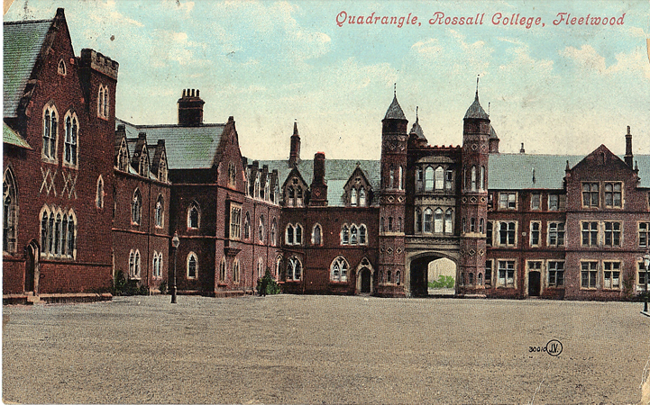
Was there chapel on that first day? Perhaps not, though there should have been, if only to calm one’s soul. But it was on such walks to chapel, especially to evensong, when the wind seemed sometimes to soar to a new dimension, tearing through one gateway into the school quadrangle and out the other, and swirling around the gazebo for good measure, that a truth about Rossall soon emerged. "Rossall will make a man of you", it was commonly said, but that referred not so much to the sports, nor to the cadet force (ghastly though that was), nor certainly to the other boys, who were for the most part a genial bunch, with all the fellowship of internees. It surely referred to the weather for, as I soon discovered, Rossall is in a climate zone of its own.
And that climate, together with an unforgiving geology, has created an area where, as Peter Bennett describes, "little grows except grass, and even that often deteriorates into marsh". The north Fylde is entirely flat, and westerly gales have caused frequent flooding over the years, most notably in 1927, while the sea wall built after that emergency lasted less than 30 years, succumbing to the storms of 1954. The clays and silt beneath the surface are unstable, making drainage difficult, and in 1960 a bore hole was sunk next to Rossall Lane to evaluate the problem. This discovered a full 600 feet of silt and mud, while no rock was reached until a depth of 1,020 feet. What trees there are are stunted, leaning against the wind, while on the coastline itself the sea might change the shore from one tide to the next, altering it by up to 12 feet at one point in December 1954. "The abatement of the storm saw the recovery of the gravel, which to the uninitiated seemed the same beach, but at a lower level", according to Fleetwood’s borough engineer, H Thompson. The shoreline has receded across the years; a village is said to have existed some hundreds of yards west of the present coast, only to be lost and abandoned in the middle ages. Small wonder that the largest house on our map, Burn (or Bourne) Hall, sometimes called ‘The House on the Hill’, sought the one patch of (relatively) higher ground on the map; dating partly from the 16th century, the building survived until the 1980s, latterly in the care of ICI.
The Rossall estate or manor was granted to the abbey of Dieulacres by King John in 1216, and remained with them until the Dissolution; in 1498 the abbott was summoned to prove his right to wrecks landed on the shore. In 1553 the estate was acquired by Thomas Fleetwood, whose family later acquired the Burn manor. There was probably an early manor house at Rossall, perhaps close to the present coastline or even further west and lost in one of many inundations, after which the Fleetwood family may have retreated east of the Wyre. At the start of the 19th century the north Fylde was sparsely populated, with just a handful of houses, while what we now know as Fleetwood was shown on maps simply as ‘Rabbit Warren’; Rossall’s first headmaster would describe the area as "a very desolate position".
 Our story properly begins in 1733 when two important if largely unrealised estates, the Fleetwoods of Rossall and the Heskeths of North Meols (near Southport) were merged through the marriage of Margaret Fleetwood and Roger Hesketh. The couple decided to live at Rossall, where they built a new Hall. Their son, Fleetwood Fleetwood Hesketh, inherited the estate on his mother’s death in 1752, and after his death in 1769 his widow, nee Frances Bold, continued to live here. One of their sons, Bold Fleetwood Hesketh, developed the estate during the last years of the 18th century, including a partial rebuilding of Burn Hall, which had a stone marked BFH 1784, and with improvement of the land following the Marsh Act of 1799.
Prints show Rossall Hall to have been a sprawling and somewhat plain building, with resistance to the elements perhaps more important than architectural refinement; it is thought to have had just five bedrooms, plus the usual servants’ quarters. After Bold’s death his brother, Robert, continued development of the estate and it would be one of his sons, Peter Hesketh (who later added ‘Fleetwood’ to his name) who inherited the estate in 1824 and who would change the history, not just of Rossall but of the Fylde. The Rossall estate may have been isolated, but the family were well in tune with metropolitan tastes and aspirations, and Peter, an MP in 1832 and a Baronet by 1838, soon set about creating the completely new town of Fleetwood, one which he envisaged being "laid out in the style of Brighton and St Leonards". It was the railway which would make this dream possible, and in 1835 – just two years after another storm had flooded the area once again – work started on the Preston & Wyre line. The route was a difficult one, for the approach to Fleetwood led straight across the salt-marshes – the easternmost of the lines shown here – and was on an embankment whose difficulties greatly increased the costs of the venture. The line finally opened in 1840.
Meanwhile, by 1837 work was underway on the new town of Fleetwood, where elegant buildings, some of which survive, were designed by the young but already fashionable architect Decimus Burton. These buildings belong to our Fleetwood map, but Burton also provided preliminary drawings for a ‘Fleetwood College’, whose classical and formally designed buildings were to house 500 boys; a similar school was also planned for girls. However, the costs of the whole Fleetwood adventure, and not least that ill-fated embankment, were pushing Sir Peter towards financial ruin. Decimus Burton returned home, work on the town all but ground to a halt, and in 1843 Sir Peter finally realised that he could only save his financial skin by selling Rossall Hall.
The recently appointed vicar of Thornton-cum-Fleetwood was the Rev St Vincent Beechey, son of the artist Sir William Beechey. He was at the forefront of moves to open a school, and was encouraged by the opening in 1843 of Marlborough School, intended at least partly for the sons of clergymen. A northern equivalent was envisaged, and after the clearance of Rossall Hall in 1844 – an occasion that saw special trains put on to bring dealers and prospective purchasers – a lease was taken on the building and 31 acres. The Hall was to be the basis for the school (it remained part of the complex until 1927, when it was demolished to make way for a new dining hall) and this opened in August 1844 with around 70 pupils.
 Progress over the first few years was difficult, not helped by a scarlet fever epidemic in 1845 from which three boys died, and another storm and inundation which, albeit not so serious as one in 1833, still destroyed farm buildings on the coast. There also appears to have been a breakdown in discipline accompanied, paradoxically, by both excessive beatings and a deeply religious atmosphere. The first headmaster, Dr John Woolley, was soon replaced by the Rev W A Osborne whose headmastership, until 1869, led to Rossall’s establishment as a major public school. Osborne developed the school’s reputation beyond the Lancastrian hinterland, bringing in boys from the south (helped by Marlborough’s ‘High Church’ reputation) and from Ulster. The Irish contingent brought colour to a sometimes austere scene, a tradition that continued into the 20th century, notably with that splendid humourist Patrick Campbell, while in my own day Irish anecdotes, often of prep school life, were always good if scurrilous value. In the 19th century the Irish boys seem to have had the capacity for trouble, either intentionally or by default, though none so shockingly as J H Hogan who, believing that "Masters are boys’ enemies and ought to be treated with insolence and contempt and defiance and everything that could vex or annoy a Master ought to be done", proceeded to lace the Rev Sleap’s bread with arsenic. This misdemeanour having been foiled, he repeated it on the master’s sugar, although luckily for all parties the act was discovered.
Many of the school’s finest buildings were opened during this era: the Sumner Chapel, named after the Bishop of Chester (later Archbishop of Canterbury) was opened in 1850, designed by the school’s architect, J E Gregan. Designed for 300 boys, the chapel quickly became too small and in 1860 further land was purchased and E G Paley commissioned to design a new chapel on the south of the school. This was consecrated in 1862, and would be extended in the 20th century with a Memorial Chapel, built 1920; the crowning glory would come later, a reredos by Eric Gill, a carving of the Crucifixion, dating from 1927 and arguably the finest piece of 20th century art in the county. Other buildings dating from Osborne’s era included the ‘Big School’, on the north side of The Square, dating from 1853 and designed by Manchester architect E H Shellard; a range of buildings in the 1860s which included the famous archway (1868), in the neo-Tudor style so popular with schools, built partly to impress visitors from a station on a proposed (but never built) Fleetwood-Blackpool railway; an indoor and heated swimming bath with a post office and shop at one end (1865-70); a pavilion (1860 but later rebuilt) and Gas Works (1861). To these should be added the ‘Lincoln Dykes’ or ‘kop’, the earth mound running around the school as a flood defence, and created in 1863, after yet another inundation.
Meanwhile the Crimean and other troubles led to a call for Volunteers and in 1860 the Rossall Rifle Volunteers were formed, as the 65th Lancashire and part of the Ulverston Battalion, and the first school ‘corps’ to form part of the proper army. During the 1867 Fenian scare, when there were fears for the security of the armoury, the boys kept their rifles, complete with (albeit somewhat blunt) bayonets, in their studies.
Also at this time Rossall, already known for its cricket – they entertained the All England XI in 1862 – was devising its own sports, Rossall Hockey and Rossall Football, both descendants from the Eton Field game, and in 1883, when the Gymnasium was built, courts were built on its eastern side for Rossall Fives. Rossall Hockey, played on the beach, survives today (does Fives?) but some of the other sports came in for criticism, not helped when a boy died of exposure on a cross country run. Rossall Football was replaced by soccer in 1881, and several boys went on to play for England. Not until 1914 would soccer be replaced by rugby, a decision taken largely to attract more inter-school competition. Even greater fame in those mid-Victorian days came from mountaineering, enormous publicity – some of it critical if admiring – coming in 1876 when three of the masters, Arthur Cust, A H Cawood and J B Colgrove (who had just left for Loughborough Grammar School) climbed the Matterhorn, along the Zermatt ridge and without guides.
Rossall sometimes has the reputation of a ‘sports’ orientated school but in fact it has an equal if not greater legacy in what might loosely be termed the arts. In music there was, of course, Sir Thomas Beecham, perhaps England’s greatest conductor, at Rossall from 1892-97, who found himself playing the big drum in the school’s military band, "a gigantic object which every five minutes I longed to heave into the nearest ditch", but who as house captain was later allowed to have a piano in his study (he retained an affection for Rossall and brought the Hallé Orchestra here in 1917); and my friend and contemporary Bill Hopkins (1954-60) whose small body of work, cut short by an untimely death, promised so much. The school’s literary connections are broad: a pupil in 1910 was the poet J R Ackersley (1908-14), later a long term editor of The Listener, while a few years earlier the Gloucestershire poet F W Harvey (1902-05) had been here. Both became prisoners-of-war – 289 Rossallians were less fortunate and perished in that war – and Harvey, "A thick-set, dark-haired, dreamy little man, Uncouth to see", as he described himself, wrote one of the greatest of all war poems,
Other literary figures included Derek Walker Smith (1923-28), better known as a politician, whose only novel Out of Step caused a furore when published in 1930, for its forthright portrayal of a public school (all copies of the book in Rossall are said to have been destroyed by a loyal master!); the fine novelist J G Farrell; and most famously of all Leslie Charles Bowyer-Yin (1922-24) who was writing for magazines while still at school and who as Leslie Charteris created ‘The Saint’. Bowyer-Yin’s father was a Singaporean, and with many from China and the far east now coming to Rossall we must hope for another thriller writer among them.
Rossall remained quite isolated until the late 19th century. The original Preston & Wyre Railway had cut straight across the salt marshes, but in 1869 work started on Fleetwood’s Wyre Dock, and the railway was improved. A line was built now curving round the edge of the marshes, the intention being that trains would use one route down and the other up, although in reality the old embankment was soon abandoned. There had also, as we have seen, been plans, unrealised, for a direct railway between Blackpool and Fleetwood, but in 1897 work started on the Blackpool & Fleetwood Tramroad, essentially a Light Railway rather than a tramway, and this opened in 1898, so kick-starting the development of Cleveleys. A station was provided for Rossall. In 1920 the Tramroad was taken over by and amalgamated with the Blackpool Corporation trams, opposition to this from Thornton UDC and the Lancashire & Yorkshire Railway being silenced by the promise of a bus link between Thornton station and Cleveleys, and a freight service over the tramroad from Fleetwood to Cleveleys. It took time for the latter to materialise, Blackpool perhaps hoping that the pledge would be forgotten. However, eventually they laid connecting lines between the railway and tramroad at Fleetwood, supplied a small electric locomotive (now in the National Tramway Museum) and in 1927 began a regular service, principally of coal, between Fleetwood’s Copse Road Depot and Thornton Gate. The service continued until 1949. The opening of Broadway outside the school gates in 1925 led to the tramroad being rerouted somewhat to the east.
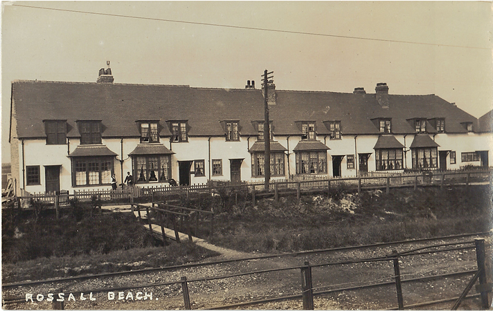
 The tramroad made the development of Cleveleys possible, and by the early 20th century this was rapidly growing into a small town. The leading light was T G Lumb, an architect and engineer who supervised construction of the Tramroad and, in 1900, became part of a consortium, the Fleetwood Estate Co, which acquired some 2,000 acres of land from the Fleetwood Estates and Thornton Estate. Work started in the Rossall Beach and Thornton Gate area, and joining Lumb on this project was the architect Edwin Lutyens, who drew up various plans for a ‘Garden City’, and designed several houses. These plans proved too ambitious but in 1906 a Cottage Exhibition was held, just south of this map, with numerous exhibition houses built, partly inspired by the success of Letchworth Garden City. These led to something of a building boom. On this map, however, we do find a group of houses that Lutyens himself designed, just prior to the Cottage Exhibition, in the two terraces at Rossall Beach (ie immediately west of College Farm). These interesting houses repay close study, especially those at the ends, facing each other across the road, where pairs of houses are effectively ‘hinged’ together around a courtyard.
If Cleveleys was becoming a seaside resort, so the much older Thornton was attracting an industrial base. As the map makes clear, the Wyre area is quite rich in salt and in the 1890s a salt works was opened by the United Alkali Co at Burn Naze, the stump of the old ‘direct’ Fleetwood line now being called the Burn Naze Siding. Until the belated opening of the Knott End Railway, communications were poor on the east side of the Wyre, where the salt mines were, and pipes were laid beneath the waters to the works. Many workers came in from the traditional salt areas of Cheshire for employment at Burn Naze, which was soon accompanied by the alkali or ammonia soda works, opened in 1893. The United Alkali Co was the successor to the Lancashire Bleaching Powder Manufacturers’ Association, a group of around a dozen chemical firms, mostly in the Widnes and St Helens area, who used the Leblanc process to produce sodium carbonate and related products, essential in the glass, paper and soap industries. Salt and sulphuric acid were the basic ingredients, but coal and limestone were also required. However by the 1890s the United Alkali Co – at one time the world’s largest chemical firm, was losing ground to those – principally Brunner, Mond – who used the relatively new Solvay process, whereby salt was reacted with ammonia and carbon dioxide. United Alkali acquired one ammonia soda works, at Widnes, and also developed the Thornton works for this purpose. Nevertheless, they remained a declining if large company (a legacy of their origins as a consortium meant they were top heavy with directors) and in 1926 the company was merged with Brunner, Mond – together with Nobel Industries Ltd and the British Dyestuffs Corporation Ltd – to form Imperial Chemical Industries Ltd, or ICI, the largest such merger the world had known. The salt works was then closed but chemical production at Thornton was subsequently increased and diversified, including chlorine derived chemicals in World War II.
The two works led to a considerable building boom, albeit largely south of this map, between 1895 and 1914 and this part of Thornton became something of a company town. A small railway halt, initially without platforms, was opened for a steam rail-motor service operated between Blackpool and Fleetwood from 1908. Transport and industrial developments have brought great changes to this area of the map, but further west there is much that survives, including Rossall School, the tramway, and Lutyens’ houses. Sir Peter Hesketh Fleetwood would be proud.
©Alan Godfrey, October 2006
Principal sources include: Peter Bennett, A Very Desolate Position and Rossall Will Be What You Make Of It (both Rossall Archives 1992); Steve Palmer, Blackpool & Fleetwood, 100 Years by Tram (Platform 5, 1998); W J Reader, Imperial Chemical Industries, A History (OUP 1970); Ralph Smedley (ed), Thornton Cleveleys Remembered (Tempus 2001); Victoria History of Lancashire, Vol VII (1912).