
 Here are the details of maps for Peckham & Camberwell:

We have published three versions of this map, showing how the area developed across the years. The maps each cover the same area, stretching from Denmark Hill station eastward to Queen's Road station and Asylum Road; and from Rosemary Road southward to Nunhead Green. Peckham Road and High Street runs west-east across the map, with tramway; further south the railways run across, with Peckham Rye station in the lower centre of the map. Other features of these very busy maps include Peckham House lunatic asylum, Camberwell Workhouse, Brunswick Square, Eagle Mill, Rye Lane, tramways and tram depot, railways incl engine sheds, St Giles church, Brunswick Square, Camberwell Town Hall, Surrey Canal with Peckham Wharf, north end of Peckham Rye Common. The following Wards are named on the map: Town Hall, St Giles, Lyndhurst, Goldsmith, Rye Lane, St Mary's and Nunhead Wards (though some extend onto adjacent maps). The map is largely part of Camberwell Borough.
The maps include extracts from early directories, those for the 1914 edition including Asylum Rd, Camberwell Grove, Choumert Rd, Grove Lane, Peckham High St, Peckham Rd and Rye Lane. As usual in this series, the 1st Edition 1871 map is especially attractive.
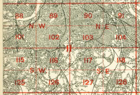
The map links up with London Sheets 90 Old Kent Road to the north, 102 Camberwell to the west, 104 New Cross to the east, 117 East Dulwich to the south.
 Follow this link for a complete list of our London maps .