
 Here are the details of maps for Banagher:

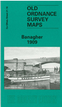
This very detailed map is double-sided for maximum coverage. The main map covers most of the little town of Banagher, which has connections with both Anthony Trollope and Charlotte Brontë. Features include the Main Street with all buildings neatly shown, railway terminus, Bridge Malt House, River Shannon, Banagher Bridge, Cuba Court, Fair Green, Fort Eliza, Crank Malt House, harbour, Birds Island, Curraghavarna and Portavolla township, Mullaghakaraun township.
On the reverse we include part of adjacent sheet 29.04 extending coverage south to include St Rynagh's RC church, St Paul's church, Mountcarteret House, Castle Garden House, Distillery, ruined Garry castle.