
 Here are the details of maps for Winchcombe:

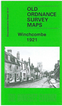
This detailed map covers the little town of Winchcombe (here spelt Winchcomb). This was one of the most important towns in England between the 7th and 11th centuries but was of less importance during the 19th century when several major employers, such as the papermakers at Postlip Mill, were outside the town. The railway station - outside the town and beyond this map - did not open until 1908. Features on this map include the town centre, Abbey remains, St Peter's church, North Street, Almsbury, Abbey Terrace, Hales Street, Footbridge. The map extends east to Stancombe Wood. On the reverse we include a commercial directory of 1894, showing the small town with a surprisingly wide range of businesses. The map is unusual in that the Gas Works is shown to be deleted (in manuscript) as part of wartime censorship by the OS in 1944.
Maps in the Godfrey Edition are taken from the 25 inch to the mile map and reduced to about 15 inches to the mile. For a full list of maps for England, return to the England page.
Alan Godfrey Maps, Prospect Business Park, Leadgate, Consett, Co Durham, DH8 7PW / sales@alangodfreymaps.co.uk / 28 October 2016