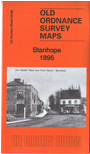
Co Durham Sheet 24.09 Stanhope 1895 - published 2016; intro by Neil Gander. ISBN.978-1-84784-997-7 
This double-sided map covers the Weardale town of Stanhope in detail.
Features include NER Wear Valley Branch with Stanhope station, Town Hall, Ashes House, Stanhope Hall, Ashes Quarries, St Thomas church, Weardale Union Workhouse,
Low Shittlehope, wagonways, goods shed, Stanhope Castle, end of NER Stanhope & Waskerley Branch, Green Head etc.
Follow this link for a complete list of our Durham maps.
You can order maps direct from our On-line Mapshop.
For other information and prices, and other areas, go to The Index Page.
Maps in the Godfrey Edition are taken from the 25 inch to the mile map and reduced to about 15 inches to the mile.
For a full list of maps for England, return to the England page.
Alan Godfrey Maps, Prospect Business Park, Leadgate, Consett, Co Durham, DH8 7PW / sales@alangodfreymaps.co.uk / 14 January 2018
 Here are the details of maps for Stanhope: