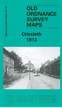
Caernarvonshire sheet 34.13 Criccieth 1913 - published 2003; intro by Alan Godfrey. ISBN.978-1-84151-436-9 
This detailed map of Criccieth covers most of the town, with coverage extending from the castle northward to Mynydd-Ednyfed, Antipodes Terrace and the reservoir.
Features include railway with station, St Catherine's church, castle, St Deiniol's church, Y Maes, High Street with indvidual buildings neatly shown, George Hotel, Bron-Eifion, Esplanade etc. On the reverse we include a contemporary directory of Criccieth.
Follow this link for a complete list of our Caernarvonshire maps.
You can order maps direct from our On-line Mapshop.
For other information and prices, and other areas, go to The Index Page.
Maps in the Godfrey Edition are taken from the 25 inch to the mile map and reduced to about 15 inches to the mile.
For a full list of maps for Wales, return to the Wales page.
The Godfrey Edition / sales@alangodfreymaps.co.uk / 18 July 2018
 Here are the details of maps for Criccieth: